2010-07-16 39 -105
| Fri 16 Jul 2010 in 39,-105: 39.5731138, -105.1707132 geohashing.info google osm bing/os kml crox |
Location
Ken Caryl Ranch, just off C-470.
Plans
The dogs and I are headed for a morning hike.
Participants
Ralph, Tanna and Hendrix
Expedition
A fifteen mile highway drive took us to Ken Caryl Ranch, a neighborhood located in a pretty cool valley between the hogback just SW of Denver and the foothills behind it. The hogback is a flat piece of rock that was pushed up by the Rocky Mountains forming, and presently lies at a tilt, so you can see the diagonal stratifications in it. Up near Boulder, this forms the [Flat Irons], and a few miles to the north of the hash the hogback shows tons of fossilized dinosaur footprints at [Dinosaur Ridge].
Photos
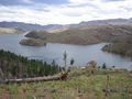
Pretty darn gorgeous.

Pretty darn gorgeous part II (on the right).
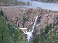
Bernoulli's principle!
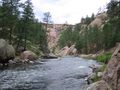
South Platte

The river is thiiiiiiiis wide.
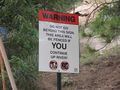
Thanks, mom. I guess I won't be getting any dessert either.


Achievements
Ralph earned the No trespassing consolation prize
|
Ralph earned the Drag-along achievement
|