2010-09-19 52 0
Location
In a conifer plantation between the Peddar's Way long distance footpath and Great Hockham, Norfolk, UK.
| Sun 19 Sep 2010 in Cambridge: 52.5101048, 0.8295401 geohashing.info google osm bing/os kml crox |
Participants
Expedition
Neil traveled by car to Great Hockham and then walked 8.8 miles through woods and farm land. Most of the walk was off tarmac, using woodland trails, a disused railway and part of the Peddar's Way. This was a worthwhile walk with the added bonus of the geohash. There were many other paths in the area so longer or shorter versions of the walk could easily be devised.
The hashpoint was about 360 metres from a military shooting range, fortunately on the safe side of the fence.
Neil's GPS receiver showed zero metres to the hashpoint for about 2 seconds. With wind, blowing trees and rain clouds, the GPS hashpoint seemed to be wandering around.
There is a GPS path documented here at WikiLoc.
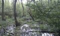
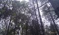
Wet Woodland
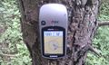
The hashpoint
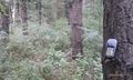
The hashpoint
The hashpoint
The hashpoint

Manic Grin - As manic as Neil ever gets.
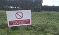
Military Firing Range
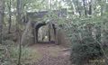
Disused Railway Bridge


