2010-10-07 45 -122
| Thu 7 Oct 2010 in 45,-122: 45.5517399, -122.6501858 geohashing.info google osm bing/os kml crox |
Location
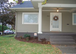
In a front lawn on a residential street in Northeast Portland
Participants
Plans
I'll go by and see how close I can get. I printed out the Google maps, and attempted to program the GPS in the dark as I walked to the car.
Expedition
Jim
Well, I finally finished up the work I was doing with folks in Asia, and headed off to the hashpoint. The directions from Google Maps didn't match the roadways very well, so I gave up and just took Hwy 30 aways and then turned when the GPS told me to go to the right. (I did remember I needed 15th street.)
I got close and parked and proceeded on foot. I was within 10 meters from the sidewalk, but I tried walking up the walkway and I got a bit closer, but I didn't want to trample the front lawn.
More details and photos will follow.
The 5000s
After work, we drove to 15th and Shaver. We walked up, took a picture, and then went out for Ethiopian food at the Blue Nile. Not every Expedition has to be an amazing adventure!
Photos
Need to be uploaded
Achievements
- Land Geohash


