2013-08-03 52 0
| Sat 3 Aug 2013 in Cambridge, UK: 52.7169253, 0.3540812 geohashing.info google osm bing/os kml crox |
Contents
Location
The west bank of the River Great Ouse just south of Kings Lynn, at the appropriately named Eau Brink Road.
Participants
| This expedition was part of a multihash by Benjw. For the other parts, see: | |||||
|---|---|---|---|---|---|
| 2013-08-03 52 0 | 2013-08-04 52 0 | ||||
Plans
Given that the next day's hashpoint is so near here, Ben plans to combine both into a nighttime expedition, driving up from Cambridge and visiting Saturday's hash just before midnight, and Sunday's hash just after. He's very happy to change those plans or to give other hashers a lift if anyone else is interested.
The Great Ouse is tidal at this point, but, conveniently, low tide is at 00:47 so with a bit of luck the hashpoint will be on the river bank and not in the water.
Expedition
Photographic documentation
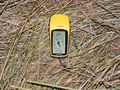
Ben's GPS showing hashpoint reached

Shiny ribbons earned
Just the one, I think. We missed 4pm, we missed midnight, we'd already met before this expedition, and we didn't end up in the river.
Benjw and PaintedJaguar earned the Land geohash achievement
|