2014-05-31 52 1
From Geohashing
Revision as of 15:57, 31 May 2014 by imported>Sourcerer (→New Expedition by Sourcerer)
| Sat 31 May 2014 in Norwich: 52.9179713, 1.3020586 geohashing.info google osm bing/os kml crox |
Location
In a small patch of woodland north of Roughton Road railway station, Cromer, Norfolk, UK.
Participants
Expedition
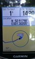
- Arrived. -- Sourcerer (talk) @52.9180,1.3020 09:21, 31 May 2014 (EDT)
This looked reachable. The weather was OK. It was the weekend. No brainer. Go and have a look. It was easily reached up a bank covered in thorny brambles.
There was one curiosity. My Garmin GPSr disagreed by 10 metres with my HTC phone GPSr. I wonder if this is because only five digits are allowed after the decimal point when setting latitude and longitude. Maybe I miss-keyed a digit. I went to both spots though so it's not a problem.
The woodland tracks I used were not on Open Street Map so I added them along with an undersized soccer pitch.
Photos
@52.9180,1.3020 Proof

@52.9112,1.2932 Selfie
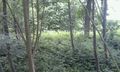
@52.9110,1.2936 Terrain
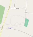
Open Street Map Additions


Achievements
Sourcerer earned the OpenStreetMap achievement
|