2015-06-11 52 1
From Geohashing
Revision as of 00:57, 12 June 2015 by imported>Sourcerer (→New Expedition)
| Thu 11 Jun 2015 in 52,1: 52.2128956, 1.3635839 geohashing.info google osm bing/os kml crox |
Location
In a field south east of Framlingham, Suffolk, UK.
Participants
Plans
Expedition one of two spanning midnight. 2015-06-11 52 1 - 2015-06-12 52 1 - ETA 22:15.
Expedition
I left home a few minutes late having dozed off. The expedition was routine although the walk was longer than usual at over 2km. The tracklog photo shows my successful attempts to follow tractor tracks. At the ten metre point, there were no obstructions between me and the hashpoint apart from potential crop damage. I'd call that coordinates reached.
Photos
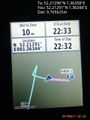
Proof. @52.2129,1.3634
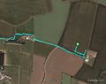
Google Earth Track


Achievements
Sourcerer earned the Consecutive geohash achievement
|
Sourcerer earned the OpenStreetMap achievement
|
Other geohashing expeditions on the same day
Expeditions and Plans
| 2015-06-11 | ||
|---|---|---|
| Aurora, Illinois | Rookiek13, Kiamx | A backyard on Ridge road in Lemont, Il |
| McMinnville, Oregon | Jim | Farm land north of Hillsboro |
| Lisbon, North Dakota | Cliff | In the middle of an active farming field just north of Kindred, ND |
| Wenatchee, Washington | Thomcat | A farmer's field near Waterville |
| Wien, Austria | atadxart, Micsnare, Crankl, B2c | Atadxart Corner of Schottengasse and Helferstorfergasse in the first distr... |
| Mannheim, Germany | DODOs Lady, RecentlyChanged | Next to a street in a residential area in Germersheim. |
| Kassel, Germany | GeorgDerReisende | The hash lay in a small piece of wood near Edermünde-Besse. |
| Norwich, United Kingdom | Sourcerer | In a field south east of Framlingham, Suffolk, UK. |