2015-10-30 49 8
From Geohashing
Revision as of 19:44, 30 October 2015 by imported>Q-Owl (Created page with "thumb|left|At the hashpoint {{meetup graticule | lat=49 | lon=8 | date=2015-10-30 }}__NOTOC__ == Location == In a field between wikipedi...")

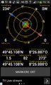
| Fri 30 Oct 2015 in 49,8: 49.7518008, 8.4481323 geohashing.info google osm bing/os kml crox |
Location
In a field between Eich and the Rhine River.
Participants
Plan
Drive to the Rhine River, take the ferry and drive/walk to the hashpoint, find some caches, drive home.
Expedition
Photos
- 2015-10-30 49 8 autumn.jpg
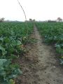
Way to the hp - between forest and nut tree
Proof
The hashpoint and view south
View north
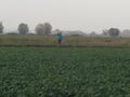
Q-Owla and view west
- 2015-10-30 49 8 south.jpg
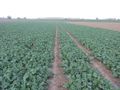
View south


Achievements / Honorable Mention
Q-Owl earned the Land geohash achievement
|
Q-Owl and Q-Owla earned the Ferry Achievement
|
Ferry ticket
Other Geohashing Expeditions and Plans on this Day
Expeditions and Plans
| 2015-10-30 | ||
|---|---|---|
| Mannheim, Germany | Q-Owl, Q-Owla | In a field between Eich and the Rhine River. |
| Norwich, United Kingdom | Sourcerer | In a field west of the A1151 between Hoveton and Dilham, Norfolk, UK. |
| København, Denmark | Phi-loci-raptor | just a few km away from work and I'm excited I might get an easy hash in a ... |