2016-04-13 52 1
From Geohashing
Revision as of 13:37, 13 April 2016 by imported>Sourcerer ([live picture] Footpath and Car [http://www.openstreetmap.org/?lat=52.29412794&lon=1.42285824&zoom=16&layers=B000FTF @52.2941,1.4229])
| Wed 13 Apr 2016 in Norwich, UK: 52.2950729, 1.4226536 geohashing.info google osm bing/os kml crox |
Location
In a field with a perimeter public footpath, south of Heveningham, Suffolk, UK.
Participants
Expedition
Photos
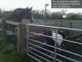
Horses @52.2948,1.4222
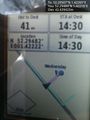
Foiled. @52.2948,1.4222
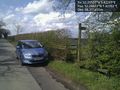
Footpath and Car @52.2941,1.4229


Achievements
Expeditions and Plans
| 2016-04-13 | ||
|---|---|---|
| Las Cruces, New Mexico | GPS Men | Chippewa Tr. in the Talavera section of Las Cruces, NM |
| Buffalo, New York | Pedalpusher | In a field by Railroad tracks in Ellicottville |
| Mannheim, Germany | DODO | A field between Berhausen and the Berghäuser Altrhein. |
| Kassel, Germany | GeorgDerReisende | The hash lay in the nature preservation area Dönche in Kassel. |
| Norwich, United Kingdom | Sourcerer | In a field with a perimeter public footpath, south of Heveningham, Suffolk,... |
Sourcerer's Expedition Links
2016-04-11 52 1 - 2016-04-13 52 1 - 2016-04-14 52 1 - KML file download of Sourcerer's expeditions for use with Google Earth.