2016-09-04 52 0
From Geohashing
Revision as of 16:33, 4 September 2016 by imported>Sourcerer ([live picture] Arrived. [http://www.openstreetmap.org/?lat=52.97455609&lon=.88901818&zoom=16&layers=B000FTF @52.9746,.8890])

| Sun 4 Sep 2016 in Cambridge, UK: 52.9745667, 0.8890309 geohashing.info google osm bing/os kml crox |
Location
On the tidal mud flats north of Stiffkey and Wells-next-the-Sea, Norfolk, UK
Participants
Plans
The hashpoint is 4 km from the nearest car parking at 52.9566, 0.9238. There is a creek to wade. Go at low tide. By noon, the tide might be low enough. By 15:30 the water will be low and the tide is fully out at 17:30.
This is a most attractive coastal area which explains my multiple visits plus many more unrelated to geohashing. The weather looks cloudy with light or heavy showers or in other words NORMAL :(
Expedition
Photos
- Photo Gallery
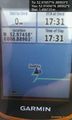
Arrived. @52.9746,.8890

Achievements
Expeditions and Plans
| 2016-09-04 | ||
|---|---|---|
| Buffalo, New York | Pedalpusher | Off Woodward Ave, Behind Innovative Integrated Solutions in Kenmore |
| Grand Rapids, Michigan | Mcbaneg | Weedy field north of M45, Allendale, MI |
| Most, Czech Republic | Danatar | on the road between Pratzschwitz and Birkwitz, two suburbs of Pirna, not fa... |
| Cambridge, United Kingdom | Sourcerer | On the tidal mud flats north of Stiffkey and Wells-next-the-Sea, Norfolk, U... |
Sourcerer's Expedition Links
2016-09-01 52 1 - 2016-09-04 52 0 - 2016-09-06 52 1 - KML file download of Sourcerer's expeditions for use with Google Earth.