2017-02-26 52 1
From Geohashing
Revision as of 17:24, 26 February 2017 by imported>Sourcerer (→New expedition)
| Sun 26 Feb 2017 in Norwich, UK: 52.1715527, 1.5623797 geohashing.info google osm bing/os kml crox |
Location
A field between Snape and Aldeburgh, Suffolk, UK.
Participants
Plans
Try this after walking with the Waveney Ramblers at Tunstall forest nearby.
Expedition
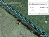
The road came within 20 metres of the hashpoint. The field was fenced and the crop was under fleece to help warm the ground. I could not reach the point with my "no damage, no disturbance" rules, so sadly, it was "Coordinates not reached".
Photos
- Gallery
Achievements
Expeditions and Plans
| 2017-02-26 | ||
|---|---|---|
| Buffalo, New York | Pedalpusher, Simon the dog, Myka the dog | In the woods of Nine Mile Creek State Forest |
| München, Germany | B2c, Micsnare | was located in a bikeshed near a housing complex in Munich, Germany. |
| Norwich, United Kingdom | Sourcerer | A field between Snape and Aldeburgh, Suffolk, UK. |
Sourcerer's Expedition Links
2017-02-13 52 1 - 2017-02-26 52 1 - 2017-02-28 52 1 - KML file download of Sourcerer's expeditions for use with Google Earth.
