2018-07-24 47 -122
From Geohashing
Revision as of 17:05, 24 July 2018 by imported>Thomcat ([live picture]South [http://www.openstreetmap.org/?lat=47.71611730&lon=-122.30325500&zoom=16&layers=B000FTF @47.7161,-122.3033])
| Tue 24 Jul 2018 in Seattle: 47.7165716, -122.3035600 geohashing.info google osm bing/os kml crox |
Location
The back yard of a house in Victory Heights, north Seattle.
Participants
Plans
Appears to be the back yard of 12026 23rd Ave NE; neighboring back yards seem to have been turned into a p-patch or community garden. May have to investigate from all sides.
Expedition
Tracklog
Photos
Thornton creek @47.7177,-122.3019
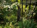
North of the point @47.7169,-122.3034
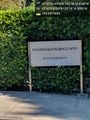
Buddhist @47.7191,-122.3046
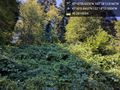
West of point @47.7165,-122.3045
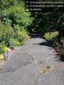
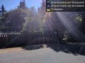
South @47.7161,-122.3033


Achievements