2008-05-31 45 -93
| Sat 31 May 2008 in 45,-93: 45.0374871, -93.2812665 geohashing.info google osm bing/os kml crox |
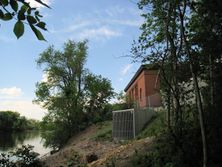
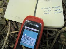
Successfully reached at 4:05pm by Joel. Was very difficult to reach but was done legally and without killing myself. Will post details and a short video later!
Unsuccessfully attempted by Mathew. I'm very interested in how you managed it. It seemed fully encompassed by barbed wire with a Fire Department Test station, a Police K-9 kennel, and the water treatment plant the coordinates seemed to pinpoint right next to the pools. I attempted this meetup but could not figure a way in that didn't involve making the police unhappy.
Joel: I departed from the trail on the north side of Camden Bridge and basically followed the outside of the barbed wire fence. I reasoned that as long as I stayed outside the fenced area I was OK, although I was aware that if someone saw me they might have told me to leave. It helped that it was a Saturday afternoon and there was no one around. I would have looked kind of strange crawling through the thick brush next to the fence. Also, I believe there's a margin of shoreline on any public waterway (the Mississippi in this case) that you're allowed to use - might be wrong on that though.
View a video of Joel's attempt to reach the spot.


