| Mon 18 Apr 2011 in 48,9: 48.9074438, 9.0279540 geohashing.info google osm bing/os kml crox |
Contents
Location
On a field. Or in a tunnel.
A little bit outside of the hamlet Pulverdingen, municipality Vaihingen/Enz.
Is the tunnel close enough?
It appears the hash - within of reasonable accuracy - hits the Pulverdinger Tunnel railway tunnel, one of many tunnels on the high speed line Stuttgart-Mannheim. The tunnel itself is 1878m long and probably not exactly straight but going in a curve with a very large radius, with the hashpoint located close to the middle, so it is a bit difficult to exactly estimate where the tunnel will pass.
If you connect the tunnel portals with a straight line, the tunnel would pass the hash slightly to the northeast. The southbound track would pass at about 10 m from the hash, the northbound track at about 15m (map here). However, since the tunnel is not exactly straight, it deviates from that straight line to the southwest - i.e. in direction of the hash. The question is, how much it deviates.
Calculating an upper limit is easy. Several sources say that the line was layed out with a curve radius of 7000m. If the entire tunnel would be built in a 7000 m curve, the maximum deviation in the middle would be 63m and with that, the maximum distance of the tunnel from the hashpoint would be 50m. However, according to the map it doesn't look like the whole tunnel is built to 7000m radius, if any of it is at all, and neither the hash is exactly in the middle. This means the actual distance will be lower than that.
In any case, it should be close enough to be called "reached" with a good conscience.
Railway traffic in the tunnel
Basically all north- and westbound long distance traffic from Stuttgart passes the point. Not all might rush through at their maximum speed.
- ICE and TGV trains: 250 km/h (280 may be allowed, but I couldn't find that out by now)
- IC and EC trains: 200 km/h
- IRE trains: 160 km/h (all tickets valid, bike transport free)
IRE and IC trains usually use cab cars which offer a certain chance that it's possible to watch the line from the driver's view. You can't be sure, though, because the drivers often block the view with a curtain. The cab is usually on the western end.
Getting there
For visiting the hash above ground usage of a bike is recommended. Distance from several train stations below 10km. However, public transport exists. Bus line 503 connects Vaihingen/Enz and Stuttgart-Feuerbach with the bus stop "Pulverdingen B10" (1.2 km from the hash) once or twice per hour, and "Pulverdingen Ort" (0.5 km from the hash) sporadically.
Below ground the hash is served by frequent long distance trains which are very expensive, and occasional IRE trains which accept also VVS tickets and the Baden-Württemberg-Ticket.
Timetable of the IRE trains:
Northbound, from Stuttgart to Vaihingen/Enz: 7:07, 9:00*, 9:31, 10:59*, 12:59*, 13:32, 14:59*, 15:31, 16:28, 16:59*, 17:31, 18:59*, 20:59*
Southbound, from Vaihingen/Enz to Stuttgart: 6:12, 6:39*, 7:04, 8:08, 8:41*, 10:08, 10:41*, 12:41*, 14:08, 14:41*, 16:08, 16:41*, 17:58, 18:41*, 20:41*
Trains marked * go to or start from Karlsruhe. Other trains end somewhere along the way.
- I managed to clear some time in the morning. My schedule:
Funny enough, this is exactly my schedule!
My plan:
- 9:31 from Dettenhausen, 10:25 at Stuttgart; or 9:37 from Tübingen, 10:38 at Stuttgart
- 10:59 IRE from Stuttgart through the hash to Vaihingen
- Bike to the hashpoint, then explore the area, continue direction Stuttgart
What kind of ticket do you plan to buy? I can upgrade my daypass to a group daypass for ~3 EUR, valid between Vaihingen and Stuttgart. --Ekorren 15:29, 17 April 2011 (EDT)
- DB-extension ticket (KVV is valid until Vaihingen), 3.05 EUR per trip with BC50. Since we'll only travel together one way, it won't save any money. Koepfel talk 16:01, 17 April 2011 (EDT)
- If it's about the same, I'll take the group ticket anyway. It's for five people, and I can try to find some stranger on the platform who would have to buy a single ticket otherwise. That means, you should only buy a single ticket. --Ekorren 16:18, 17 April 2011 (EDT)
Participants
Expedition
First tunnel visit (Koepfel)
Koepfel took a RE-train from Karlsruhe to Vaihingen (Enz). There, he waited for the IRE train, which unlike the RE (which goes to Stuttgart via Bietigheim-Bissingen) runs on the highspeed line between Mannheim and Stuttgart and also through the Pulverdinger Tunnel, in which today's hashpoint fell.
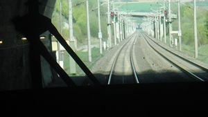
He positioned himself in the last car, a cab car, through which's windshield he filmed going through the hashpoint, see the screenshot on the right. Video might be uploaded eventually
More to be written.
Second tunnel visit (Ekorren and Koepfel)
(Ekorren and Koepfel meet in Stuttgart and run through the hashpoint again)
Koepfel and Ekorren earned the Going deep geohash achievement
|
Above-ground visit
(Ekorren and Koepfel bike from Vaihingen to the hashpoint)


