Implementations/Broken
Miscellaneous geohashing utilities that are known not to work any longer
Contents
Geco
| This implementation IS FULLY 30W-compliant. |
A re-implementation of the calculator above using leaflet/cloudmade and the JSON web service below. By using geo.crox as a data source, it is hopefully more reliable than the official map. It also shows the global hash on the map, which you may only notice when it comes into range anyway.
Parameters:
- lat - latitude of the initial graticule
- lon - longitude of the initial graticule
- zoom - initial zoom level
- date - initial date in YYYY-MM-DD format
e.g: http://relet.net/geco/?date=2005-05-26&lat=37&lon=-122&zoom=8
Hackish Bitcoin-based Python Implementation
| This implementation IS NOT 30W-compliant. |
Implementation is broken, as far as I can see: The json service queried does not provide the "open" symbol queried. I believe MtGox does not have an opening at all.
MarkTraceur made this to test what Geohashing would look like using a different financial source. It's based on the opening price of Bitcoins in USD at Mt. Gox. You can change the site you use, the coordinates, or just about anything pretty easily. It will get nicer-looking as time goes on.
It is here: https://github.com/MarkTraceur/geohash-btc
Feel free to fork it and/or send feedback through GitHub!
- Michi did some improvements and bug fixing on Marks original script:
- Since bitcoincharts removed the "open" field in their data, the script uses the price at midnight for the calculation.
- Support for the Globalhash.
- 30W compliant.
- Support for other markets than Mt.Gox.
- More map services.
- The code is in his fork. Unfortunately Mark does not respond to Pull Requests, so it looks like the fork won't get merged back.
Former geohash location suggester
No longer available as of 2012.
| This implementation IS PARTIALLY 30W-compliant. not compatible for dates before 2008-05-27 |
Geohash Recommender - This website doesn't seem to work as of 12-Jun-09
Yet another implementation in Python is here as well. It does the same as the ones above but also gives "validation" information. Lets you know if the geohash location is under water and thus if its a valid place to go party. Using this it attempts to suggest the "best" alternative geohash by checking all neighbouring grid locations. I'll add more terrain recognition if people like it. The code is over here Source Code
Bugs
- There are a few, it needs a few refreshes to get the whole tagging right. It also has trouble guessing the terrain type occasionally. Refreshing it makes it work but its a problem im looking into, have a look at the code and help if you can :)
- Gives me a false location for May 28 and 29, 2008, which aren't yet known anywhere in the world according to the algorithm. --Tim P 21:29, 24 May 2008 (UTC)
- But... thos dates aren't real yet. There is no dow result. Granted it should give an error instead of giving _something_ but...
- As of 05:06, 26 May 2008 (UTC), this gives locations for May 27-30 west of 30W and for May 28-31 east of 30W, i.e., four days beyond what should be calculable as of that time. Beyond those dates, it gives a proper error message stating that no Dow is available. I think temporary data were added to the implementation for testing purposes; these should be removed. --Tim P
- One could interpret the algorithm such that, for any date in the future, one is to use "the opening price from [DOW's] previous day of active trading is used", i.e., the most recent trading day. Obviously, this would lead to the location changing as the day approaches but, in a random spontaneous adventure generator, that seems almost mathematically pure. I mean, that's just what happens when you try to generate spontaneity too far into the future, yes? ;) Ted 00:19, 30 May 2008 (UTC)
- But... thos dates aren't real yet. There is no dow result. Granted it should give an error instead of giving _something_ but...
- Electronicwar website seems to be no longer functioning. Jiml 00:29, 13 June 2009 (UTC)
Active Geohasher
| This implementation IS FULLY 30W-compliant. |
Active geohasher was a web application by Sermoa which provided resources for geohashers. The site used to be able to send email, but resource limits have prevented it from doing so for the time being. One could use a browser to view a page containing the address, distance from your home location, and useful links. It also told you the globalhash.
The site provided graticule integration with twitter, flickr and youtube. A google earth feed was provided per gratiucule. Every geohash had a page showing various google maps, useful links and a PDF poster which you could download and print to take to the geohash.
Active geohasher is open source (written in Ruby on Rails). Please contribute if you have ideas or would like to translate it into a different language. There is also a twitter account that delivers news and direct message geohashing notifications: @activegeohasher
As of May 2013, the website has been down ("Offline for Maintenance") for several months. As of 2021, it only displays a 404 error page.
Peeron
| This implementation IS FULLY 30W-compliant. |
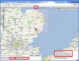
The original interactive coordinate calculator was found at http://carabiner.peeron.com/xkcd/map. Here are some notes on Using the Coordinate Calculator. The common URL, http://xkcd.com/geohashing, redirects here.
Any problems or issues should be mentioned to Zigdon either on the wiki or in the Geohashing IRC channel, as well as posted at Talk:Implementations.
As of 2022, this implementation is broken.

