| Tue 8 Jul 2008 in Copenhagen: 55.8055027, 12.5224928 geohashing.info google osm bing/os kml crox |
About
Hash: 55.788475, 12.282822
Closest town: Ganløse
Surroundings: Public road, fields.
Weather forecast: Cloudy, clearing during the day. Showers in the northwestern areas (i.e. Jutland).
Expeditions: J0e
The geohash for 2008-07-16 55 12 was located at the Almagerbakke/Råhøjvej intersection near Ganløse.
J0e
There's really not much to tell about today's expedition. A gravel covered dirt road and a wheat field and nothing more. The hash was located at the edge of the field right beside the intersection and not particularly hard to find, and GPS assistance was not needed.
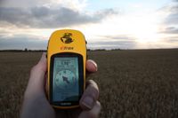
Well, ask Murphy, and he will tell you that in such a case, a cranky old GPS like "Old Yeller" will work like a charm. It did, and the drift was within a couple of meters.
There's a bog area called Oremosen and a forest in the area, but it got rather late, so I didn't have time to check it out as I was running out of light.
Apparently no-one else showed up.

