2023-01-28 45 -123
| Sat 28 Jan 2023 in 45,-123: 45.1572106, -123.1638864 geohashing.info google osm bing/os kml crox |
Location
Off of Oregon Highway 233, near Amity
Participants
Expedition
Four years ago, the 2019-02-03 45 -123 expedition involved a scenic farmland run out of the town of Amity. Today's hashpoint, a few miles away, looked fairly marginal-but-possible, and also offered me an opportunity to take a drive in the country and revisit that old run.
On the drive out, I eyed the hashpoint area from the road; it was down in a ravine, and looked like it might well be pretty darn swampy this time of year, possibly even in a pond; also, it exposed to the highway but with no convenient place to pull over. I decided to defer the decision on whether to try for it until after I ran.
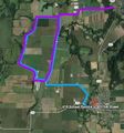
It turned out not to be possible to actually replicate the run, as the bridge west of Amity is closed for repairs. But, I was able to mostly replicate it, or the best parts anyway.
After the run and filling the gas tank, I headed back towards the hashpoint site, at which point it began to rain heavily. "Eh, hell with it," I said, and headed on home.
Faux Tracklog
The 2019 run in blue; the 2023 "Bridge Out" version in purple. The actual 2023 hashpoint was a few miles east of here.
