| Thu 18 May 2023 in -38,146: -38.2135071, 146.3504408 geohashing.info google osm bing/os kml crox |
Location
In the bottom of a disused coal mine, near Morewell.
Participants
- Rhonda
- work friend
- work experience person
Expedition
Felix noticed that the day's hash fell inside an old coal mine. His friend Rhonda's job was to rehabilitate old coal mines, and that she lived and worked near this one. Suitably alerted, Rhonda set out during the day to achieve this.
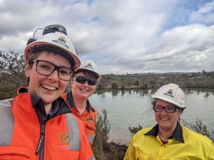
She took a co-worker and a work experience person. They got very close to the hash at the bottom of the open cut brown coal mine. However, due to a pool of water, they were only able to get to within 15m of the hash.
This is the explanation for the existence of the water: it's part of the surface water management system for run-off within this pit. It's a local depression in an elevated backfill area too collect the (ahem, mildly acidic) run-off. There's a pipe in the east side where the overflow runs into the next pond and then down into a large lake that we use to fight fires.
This was both very lucky - a rare Restricted Area hash in the exact place Rhonda had access to - and very unlucky - very little of the bottom of the coal mine was covered in water but the exact hash location was.
I've added the Restricted Area achievement below for an honourable mention, even though it doesn't really count.
-Report by Felix Dance.
Photos
Achievements
Rhonda earned the Restricted area achievement
|


