2023-10-14 41 -117
| Sat 14 Oct 2023 in 41,-117: 41.5873906, -117.9453599 geohashing.info google osm bing/os kml crox |
Location
In sagebrush off Nevada 293, west of Orovado.
Participants
Expedition
I hadn't thought too hard about what to do after the eclipse, so after 2023-10-14 40 -116 I stopped in Winnemucca to plan the rest of the day. The little shop I randomly picked out turned out to be a new-agey tea and smoothie joint -- no coffee! -- with a lot of "natural healing" rhetoric going on; given Winnemucca's bikers-'n'-casinos reputation, I was pretty darn charmed.
Refreshed by my naturally-healing tea and smoothy, and having refueled and found coffee at a truckstop 20 miles north of town, I proceeded to tiny Orovada, continued 7 miles west, and took another short hike in sagebrush to the hashpoint. More great scenery, and another graticule pioneered for geohashing!
I trusted the Nevada State Highway Map, fool that I am, that the gravel road would be a short cut back south to Nevada 140, but it got smaller and smaller and then effectively dead-ended in a rancher's front yard. Something resembling a road continued south, but even with the Expedition Vehicle, it wasn't a road I was willing to travel. So, there was a lot of backtracking. But then, I was geohashing! Backtracking is kind of baked into the enterprise.
Photos
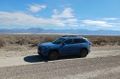
The vehicle at the jump-off point

Me, having jumped off and hiked in
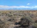
View to the east
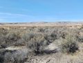
View to the west
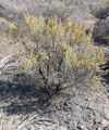
The hashpoint sage plant
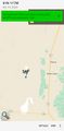
The location at a broad scale

The location at a narrow scale


