| Thu 1 Aug 2024 in Seattle: 47.7296678, -122.3267523 geohashing.info google osm bing/os kml crox |
Location
North Seattle neighborhood, at the Y between two diverging streets.
Participants
Plans
Stop by when back in town
Expedition
I've been on vacation in north eastern Washington, with inaccessible hashpoints around me (< 20km) each day. I noted this point was a possibility before beginning my 500km return trip on Thursday morning.
The two dimensional top down map made this look like a gentle break between two roads; the aerial view showed some foliage. A simple tree to duck under perhaps? The neighborhood is near some construction, and quite close to Interstate 5. There is a concrete sound barrier wall, but it is wholly insufficient to mask Thursday late rush hour traffic noise.
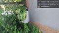
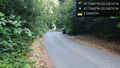
What was 2D on the map was a relatively steep downhill in person. The battered sign showing the two streets seemed backwards to me - perhaps confusing to delivery drivers. What looked like foliage was a tree and a whole lot of sticker-guarded berries below. I wondered if I could lean in close, but rarely got below 5 meters distant. Mother nature...
Just south of the point is Lakeside middle school, and just north Lakeside high school, the alma mater of a certain Redmond based billionaire.
Tracklog
Photos
Sideways again, hrmmph. West of hash point. @47.7294,-122.3274
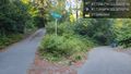
Bet this confuses delivery drivers... @47.7296,-122.3271
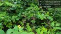
Stickers & berries @47.7296,-122.3268

Geohasher @47.7296,-122.3268
View east, towards freeway @47.7296,-122.3268
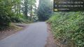
View west / up hill, to hashcar @47.7296,-122.3268

Nearby school @47.7318,-122.3288


