2010-06-26 47 11
| Sat 26 Jun 2010 in Innsbruck, Austria: 47.5617815, 11.2626874 geohashing.info google osm bing/os kml crox |
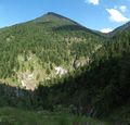
At around 1650m above sea level, at the edge of the forest line below the summit of Simetsberg, east of Eschenlohe. dawidi from 49 12 attempted to get there.
Expedition
I got up at 4:00 and left home at 6:50 for the central station. After changing trains in Munich, I arrived in Eschenlohe at 10:50, and located a bakery to buy something to nom on during the day, since Simetsberg was supposed not to have a restaurant on it. When I got to the trailhead, I cycled past a row of cars with people unpacking mountain bikes. The forest track went uphill through the forest, meandering along the side of the valley. For the first few kilometers, many cyclists overtook me on their light and sportive bikes and with no luggage of any kind except drinking water, but later during the ascent I caught up to them again. Except for a few somewhat-less-steep segments and a short descent along the side of Pustertallaine (a steep mini-valley carved by a mountain stream), the track went uphill continuously and was about as steep as I could manage to climb with my Rohloff hub in the lowest gear. It was also rather full of loose bits of rock, which made resuming pedaling after a break somewhat tricky (even for the more sportive cyclists).
Higher up the mountain, the trees became less dense, offering less shade to take breaks in, but also allowing more spectacular views. At one of the many, very welcome, cool springs by the wayside, I chatted a bit with another cyclist, and it turned out everyone except me was heading to an alpine hut near the summit of "Hohe Kisten" (high crates, literally), a different nearby mountain, to eat there and then coast back down. Since the Wikipedia article about Simetsberg mentioned it lacking a serviced hut, that was somewhat unexpected, but of course it didn't make me change my plans. The cyclist I talked to also mentioned he needed to be back in Munich by 16:00 for an appointment...
Finally I got to the saddle point between the two summits, where I expected to find a somewhat less cycleworthy trail branching off to the left, to get me towards the southeast of Simetsberg from where a footpath should get me to the summit. The path didn't exist... like, at all. There was a steep slope and relatively thick forest where OSM said the trail should be, and a short stub of trail followed by similar terrain where the Garmin Topo map said it should be. A bit further along the main track, a signpost indicated a trail leading roughly in the right direction, but the poor excuse for a trail that started behind it disappeared a few meters after the first turn.
I was now at 1530m elevation - nearly a full kilometer of elevation higher than I started - a new record for me, both in absolute elevation reached by bike, and in elevation difference climbed. Lacking other choices, I followed the main track some more, took a picture at the spot where the previous day's geohash had fallen about 50m downhill from the track, and then arrived at another fork with a signpost. To the right, the main track would have continued uphill presumably towards Hohe Kisten, but I took the track to the left, which was in a slightly worse condition and led steeply downhill towards Wildsee, a remote-ish little lake at the bottom of a hollow, noteworthy for being shielded from civilization noises on all sides. Eventually I had to get off and push my bike to avoid slipping on the loose bits of rock.
The lake was indeed very quiet and beautiful, and I spent a while there, ate something and just enjoyed the place. At the east end of the lake, I found another very... um, unobtrusive, trail, which according to my maps would lead me to the northeast around the summit. By then, I had already given up on reaching the summit, but would have liked to at least use a different route (Eschenlaine valley, with the Asamklamm gorge) on the way back to Eschenlohe. After pushing, sometimes carrying, my bike along the trail for maybe 200 meters, I came across another sportive-type cyclist carrying his payload-free bike over the rocks and fallen trees, and he advised me that the path wouldn't improve until about 1.5 km from where we stood. At that point, not willing to carry my bike for the next hour or two and possibly hurting myself along the way, I gave up on the Eschenlaine route, turned back towards the lake, and pushed my bike up to the main track. I took the way down slowly - much slower than the other cyclists, some of which chased down the track at 30kph and would have quite unavoidably veered down the cliffs into the valley if there had been the slightest obstacle in their way.
I coasted out of the forest above Eschenlohe, and into much warmer air than I had gotten used to higher up. There was just enough time left to find a small geocache for consolation and hop on IRC for a few minutes at the station before my train arrived to take me home.
All in all, a very successful failure :-)
dawidi earned the Done with Nature consolation prize
|


