2010-07-31 60 10
| Sat 31 Jul 2010 in 60,10: 60.0601459, 10.2629227 geohashing.info google osm bing/os kml crox |
Location
In Tyrifjorden.
Participants
Plans
Water hash!
Expedition
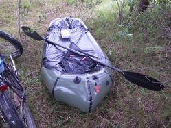
Before setting out on this expedition, I mentioned in the channel that I was hoping this expedition would adhere to the 80:20 rule.. with 80% preparation and 20% execution. That was after I had searched the aerial pictures for a decent place to launch a boat, learned how to inflate a raft with an inflation bag, sewn my seat to the raft... Mother Nature with her wicked sense of humour decided to make that true.
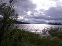
I eventually set out and cycled towards Tyrifjorden, where I easily found the tractor trail to the water. I just had to pass behind that farmhouse, and follow it. The tiny headland I wanted to launch my boat from was already covered with two canoes, a motorboat and some deck chair suites. It was obviously used for relaxation and boating, as I intended to. I would probably have asked for permission to access, but since there was no one to be seen, and we've got the Allemannsretten Freedom to Roam laws, I figured I would be fine.
One reason why there was no one to be seen might have been that it was a bit windy. Some would call it a storm. I locked my bike, eyed the fast-moving clouds suspiciously, and began to prepare my expedition. With the wind like this, I wouldn't want to set out yet, but there's nothing wrong in being prepared. I decided to wait for half an hour, until that big rainy cloud would have passed over my head. I waited a bit longer, and the cloud passed. The wind did not cease however, and thus I surrendered to my common sense not to go on the water today.
I packed my stuff and cycled home. At least I carved me some eating sticks, which should be useful in future expeditions.
Tracklog
Photos
|


