2012-08-08 52 0
| Wed 8 Aug 2012 in Cambridge: 52.9713206, 0.9072514 geohashing.info google osm bing/os kml crox |
Contents
Location
On mud flats north of Stiffkey, Norfolk, UK. It was on terrain which floods twice per day on each high tide. Wikiloc Tracklog
Participants
- Sourcerer
- Sourcerer made an accidental retrohash on the way to 2015-06-29 52 0.
Planning and Expedition
This looks possible at low tide. I've got quite a lot going on right now but the terrain is wild and calling me so I'll try to make the time. I checked the tide tables and decided that an arrival at about 07:30 would be OK.
- Arrived. -- Sourcerer @52.9713,.9072 07:47, 08 August 2012 (GMT+01:00)
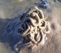
All went more or less to plan but there was some minor drama. The dawn alarm woke me up and after breakfast there was a calm drive to the wonderful countryside of north Norfolk. The walk was not too long but it did cross black slippery smelly anaerobic mud. The terrain included mud with shallow water full of green algal slime. This is totally cool at night because there are many bio-luminescent creatures and rings of blue/green light spread from your footprints as you walk. If you did hop-scotch, you could make Olympic rings. There were zones with thousands of lug worm casts. Another zone was full of bivalve and razor shells. The hashpoint was almost dry and razor shells were used to make an XKCD marker. Of course the rising tide will have washed this away about two hours after placement.
The weather was warm and sunny making a pleasant change from the cool and record wetness the UK has been having. The sea looked miles away so a slow wandering route was selected for the stroll home. This was nearly a bad mistake. The last creek looked ominously wide and the incoming tide was already flowing quite fast. I was on the wrong side. There was a plan B, to go upstream to shallower water where a safer crossing might be made.
Some wooden posts suggested the creek was not too deep so I opted to wade across right there. All was well for the first 75%. This was a geoflash wade into water, waist deep, and the sand holes could be seen and avoided. Of course creeks are tricky and this one deepened suddenly causing a minor panic. It was now chest deep and my rucksack began to flood. Removing a rucksack in chest deep fast flowing water whilst trying not to wet the GPS receiver and Android phone would have greatly entertained any spectators. It's always fun watching other people failing to stay dry. Sadly there were no watchers. 15 minutes later the creek would have been neck deep and 30 minutes later a swim would be needed. I was in no danger but the electronic technology nearly came to grief. I prefer to leave a wider safety margin than that when drowning might be the unintended side effect.
My watch, submersible to 50 metres, failed though. I had to buy a new one.
Photos
@52.9713,.9072 The Marker
Achievements
Sourcerer earned the Serendipitous Retrohash Achievement
|
Expeditions and Plans
| 2012-08-08 | ||
|---|---|---|
| Perth, Australia | nick mz | On a car park next to the Perth Football Club's Eftel Oval. |
| San Francisco, California | Anniepoo, Nija | Sunnyvale Tennis Center, just south of El Camino Real off Matilda. The act... |
| Boston, Massachusetts | Someone went | Right near some decayed piers, a park, and a residential area in East Bosto... |
| Cambridge, United Kingdom | Sourcerer | On mud flats north of Stiffkey, Norfolk, UK. It was on terrain which floods... |
Sourcerer's Expedition Links
2012-08-01 52 1 - 2012-08-08 52 0 - 2012-08-09 52 0 - KML file download of Sourcerer's expeditions for use with Google Earth.


