2015-08-16 43 -84
| Sun 16 Aug 2015 in 43,-84: 43.4949137, -84.9682920 geohashing.info google osm bing/os kml crox |
Location
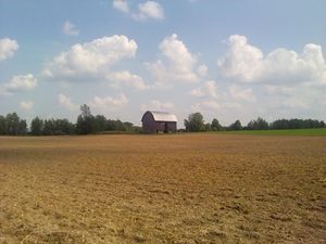
plowed field next to Fremont Rd, Blanchard, MI, USA
Participants
Expedition
Another try at 43 -84, successful this time after the failed 2015-07-25 43 -84 attempt.
The hashpoint looked to be in a hayfield about 50 feet off the road. It was still possible we'd have no access, but it was a nice day and Rebekah needed the driving practice anyway, so we decided to try it. The satellite map showed an interesting feature: an Amish horse and buggy on the road.
When we arrived the field was not only easily accessible (no fence, no signs) but recently plowed or harrowed. It was a very short walk from road to hashpoint. There were interesting stacks of grain in the field to the north that looked hand-tied. We did not see any buggies, though. We needed to get R. back to town for an outing with friends that had been organized while we were enroute so we didn't linger.
Photos
Achievements
George achieved level 7 of the Minesweeper Geohash achievement
|


