Difference between revisions of "1957-09-06 -34 149"
From Geohashing
imported>Benjw m (retro cats) |
m (More specific location) |
||
| (5 intermediate revisions by 3 users not shown) | |||
| Line 1: | Line 1: | ||
| − | + | [[Image:{{{image|1957-09-06 -34 149 site.JPG}}}|thumb|left]] | |
| − | |||
| − | |||
| − | |||
| − | |||
| − | |||
| − | |||
| − | |||
{{meetup graticule | {{meetup graticule | ||
| lat=-34 | | lat=-34 | ||
| Line 15: | Line 8: | ||
}} | }} | ||
| − | |||
| − | |||
== Location == | == Location == | ||
| − | + | About 100m into a cattle field, just off the Collector Road, north of Collector, New South Wales. | |
== Participants == | == Participants == | ||
| − | + | [[User:1PE|1PE]] | |
| − | |||
== Plans == | == Plans == | ||
| − | + | This was my Displaced Origin (55th birthday) hash, rather than -35 149 that was in quite wild country! | |
== Expedition == | == Expedition == | ||
| − | + | ===1PE=== | |
| + | I had planned this for about 2 weeks. Then, I discovered on the day that the hash [[2012-09-06 -35 149]] was on the way, so I combined the two. | ||
| − | + | The field was easily identified, I entered through the farm gate, paced out into the field then along the fence the required distance. Pics were taken. | |
| − | |||
== Photos == | == Photos == | ||
| − | + | ||
| − | |||
| − | |||
<gallery perrow="5"> | <gallery perrow="5"> | ||
| + | File:1957-09-06 -34 149 site.JPG|Stupid grin, just like a baby's but 55 years on! | ||
| + | File:1957-09-06 -34 149 house.JPG|House to the north. | ||
| + | File:1957-09-06 -34 149 gates.JPG|Looking along the fence, to the hash(!), with the path flattened by cattle. | ||
| + | File:1967-09-06 -34 149.JPG|Bushranger Hotel, Collector NSW (celebrating a thief!) | ||
| + | File:1957-09-06 -34 149 Nelson.JPG|Monument to the killed policeman, beside the hotel. | ||
| + | |||
</gallery> | </gallery> | ||
== Achievements == | == Achievements == | ||
{{#vardefine:ribbonwidth|800px}} | {{#vardefine:ribbonwidth|800px}} | ||
| − | + | {{Displaced origin geohash | |
| + | | birthlatitude = -32 | birthlongitude = 151 | birthdate = 1957-09-06 | on = 2012-09-06 | attemptlatitude = -34 | attemptlongitude = 149 | name = [[User:1PE|1PE]] | image = 1957-09-06 -34 149 site.JPG | ||
| + | }} | ||
| − | |||
| − | |||
| − | |||
| − | |||
| − | |||
| − | |||
| − | |||
| − | |||
| − | |||
| − | |||
| − | |||
[[Category:Expeditions with photos]] | [[Category:Expeditions with photos]] | ||
| − | |||
[[Category:Expedition without GPS]] | [[Category:Expedition without GPS]] | ||
| − | |||
| − | |||
| − | |||
[[Category:Retro coordinates reached]] | [[Category:Retro coordinates reached]] | ||
| − | + | {{location|AU|NSW|UL}} | |
| − | |||
| − | |||
| − | |||
| − | |||
| − | |||
| − | |||
| − | |||
| − | |||
| − | |||
| − | |||
| − | |||
| − | |||
| − | |||
| − | |||
Latest revision as of 11:19, 1 August 2020

| Fri 6 Sep 1957 in -34,149: -34.8990810, 149.4489370 geohashing.info google osm bing/os kml crox |
Location
About 100m into a cattle field, just off the Collector Road, north of Collector, New South Wales.
Participants
Plans
This was my Displaced Origin (55th birthday) hash, rather than -35 149 that was in quite wild country!
Expedition
1PE
I had planned this for about 2 weeks. Then, I discovered on the day that the hash 2012-09-06 -35 149 was on the way, so I combined the two.
The field was easily identified, I entered through the farm gate, paced out into the field then along the fence the required distance. Pics were taken.
Photos
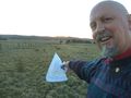
Stupid grin, just like a baby's but 55 years on!
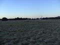
House to the north.
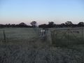
Looking along the fence, to the hash(!), with the path flattened by cattle.
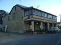
Bushranger Hotel, Collector NSW (celebrating a thief!)
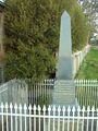
Monument to the killed policeman, beside the hotel.


Achievements
1PE earned the Displaced origin geohash achievement
|