Difference between revisions of "1990-11-24 47 11"
imported>The T-Man |
imported>The T-Man (→The_T-Man) |
||
| Line 15: | Line 15: | ||
== Retro Expedition == | == Retro Expedition == | ||
===[[User:The_T-Man|The_T-Man]]=== | ===[[User:The_T-Man|The_T-Man]]=== | ||
| − | As I already wrote on my profile page, I wasn't too pleased when I was told that I had to do 9 months of social service (called "Zivildienst" = "civil service") because of our drafting system here in Germany. This also includes a stay of four days in some sort of school to take part in classes on politics, ethics and society issues. However, I was quite happy when I found out that my Displaced Origin hashpoint was only 5.8km away from said school. | + | As I already wrote on my profile page, I wasn't too pleased when I was told that I had to do 9 months of social service (called "Zivildienst" = "civil service") because of our drafting system here in Germany. This also includes a stay of four days in some sort of school to take part in classes on politics, ethics and society issues. However, I was quite happy when I found out that my Displaced Origin hashpoint was only 5.8km away from said school. Unfortunately my class didn't end until 4.30 p.m., so I had to walk most of the distance in the dark. |
| − | Unfortunately my class didn't end until 4.30 p.m., so I had to walk most of the distance in the dark. | + | |
| − | My path led me out of the village and for about 5km along a small street through a forest. Then, I passed through a village that was located on a small hill and went left towards a farm and small bits of forest. Finally, I arrived in front of some sort of quarry that streched at least 100m into the dark. Staying on the path, I could approach the hashpoint up to about 27m. While the satellite image had shown more or less grassy plains, in the meantime someone seemed to have planted a forest there, consisting of pines ranging from 4-10m in heigt that were planted 30-100cm(!) apart from each other. Even more demotivating, the terrain on the edge of the forest was incredibly steep. Since I didn't want to have gone all the way in vain, I grabbed on to some pines and climbed up into the forest. I fought my way forward through the pines, until, after about 3m I was stopped by a chain-link fence. I climbed over it and made my way through the thicket until I was up to 2.8m away from the hashpoints, which apparently was located directly at the base of a big pine tree (photo of hashpoint and Stupid Grin are missing, because my camera had already gotten quite wet). Crouching below the trees, I realized that I hadn't set a waypoint on my GPS when I had left the path. Since I couldn't walk in a straight line long enough for the GPS to attune to my direction of movement, I was left pretty disoriented, calmed only by the fact that the forest appeared to be limited on all four sides from outside. So I fought my way onwards, probably circling around for a couple of times, until I found myself standing at the edge of the quarry. I carefully climbed back down and started my way back. | + | My path led me out of the village and for about 5km along a small street through a forest. Then, I passed through a village that was located on a small hill and went left towards a farm and small bits of forest. Finally, I arrived in front of some sort of quarry that streched at least 100m into the dark. Staying on the path, I could approach the hashpoint up to about 27m. While the satellite image had shown more or less grassy plains, in the meantime someone seemed to have planted a forest there, consisting of pines ranging from 4-10m in heigt that were planted 30-100cm(!) apart from each other. Even more demotivating, the terrain on the edge of the forest was incredibly steep. Since I didn't want to have gone all the way in vain, I grabbed on to some pines and climbed up into the forest. I fought my way forward through the pines, until, after about 3m I was stopped by a chain-link fence. I climbed over it and made my way through the thicket until I was up to 2.8m away from the hashpoints, which apparently was located directly at the base of a big pine tree (photo of hashpoint and Stupid Grin are missing, because my camera had already gotten quite wet). Crouching below the trees, I realized that I hadn't set a waypoint on my GPS when I had left the path. Since I couldn't walk in a straight line long enough for the GPS to attune to my direction of movement, I was left pretty disoriented, calmed only by the fact that the forest appeared to be limited on all four sides from outside. So I fought my way onwards, probably circling around for a couple of times, until I found myself standing at the edge of the quarry. I carefully climbed back down and started my way back. |
| + | |||
| + | When I got back into the I was more than happy to stop for some tea, beer and a nice Bavarian "Brotzeit" in a inn. When I entered it, people quite wondered about the strange person, covered with snow and pine needles. My explanation that I had "somehow gotten into some shrubberies" did not seem to completely satisfy them. | ||
| + | |||
| + | My way back was rather unspectacular, again longer than I expected (the overall walking distance was 16km) and still very creepy (Though I should have known better, I couldn't completely negate my constant fear of being attacked by some sort of Yeti-like creature. I guess, forests at night will always feel creepy to me.). I arrived back at the school around 9.15 p.m. | ||
| + | |||
== Photos == | == Photos == | ||
<!-- Insert pictures between the gallery tags using the following format: | <!-- Insert pictures between the gallery tags using the following format: | ||
Revision as of 12:30, 2 February 2011
| Sat 24 Nov 1990 in 47,11: 47.8045562, 11.4939367 geohashing.info google osm bing/os kml crox |
Location
The_T-Man's displaced origin geohash coordinates for the Innsbruck graticule (47, 11) are near some sort of quarry in rural Bavaria.
Participants
Retro Expedition
The_T-Man
As I already wrote on my profile page, I wasn't too pleased when I was told that I had to do 9 months of social service (called "Zivildienst" = "civil service") because of our drafting system here in Germany. This also includes a stay of four days in some sort of school to take part in classes on politics, ethics and society issues. However, I was quite happy when I found out that my Displaced Origin hashpoint was only 5.8km away from said school. Unfortunately my class didn't end until 4.30 p.m., so I had to walk most of the distance in the dark.
My path led me out of the village and for about 5km along a small street through a forest. Then, I passed through a village that was located on a small hill and went left towards a farm and small bits of forest. Finally, I arrived in front of some sort of quarry that streched at least 100m into the dark. Staying on the path, I could approach the hashpoint up to about 27m. While the satellite image had shown more or less grassy plains, in the meantime someone seemed to have planted a forest there, consisting of pines ranging from 4-10m in heigt that were planted 30-100cm(!) apart from each other. Even more demotivating, the terrain on the edge of the forest was incredibly steep. Since I didn't want to have gone all the way in vain, I grabbed on to some pines and climbed up into the forest. I fought my way forward through the pines, until, after about 3m I was stopped by a chain-link fence. I climbed over it and made my way through the thicket until I was up to 2.8m away from the hashpoints, which apparently was located directly at the base of a big pine tree (photo of hashpoint and Stupid Grin are missing, because my camera had already gotten quite wet). Crouching below the trees, I realized that I hadn't set a waypoint on my GPS when I had left the path. Since I couldn't walk in a straight line long enough for the GPS to attune to my direction of movement, I was left pretty disoriented, calmed only by the fact that the forest appeared to be limited on all four sides from outside. So I fought my way onwards, probably circling around for a couple of times, until I found myself standing at the edge of the quarry. I carefully climbed back down and started my way back.
When I got back into the I was more than happy to stop for some tea, beer and a nice Bavarian "Brotzeit" in a inn. When I entered it, people quite wondered about the strange person, covered with snow and pine needles. My explanation that I had "somehow gotten into some shrubberies" did not seem to completely satisfy them.
My way back was rather unspectacular, again longer than I expected (the overall walking distance was 16km) and still very creepy (Though I should have known better, I couldn't completely negate my constant fear of being attacked by some sort of Yeti-like creature. I guess, forests at night will always feel creepy to me.). I arrived back at the school around 9.15 p.m.
Photos

The social service school that was my base of expedition
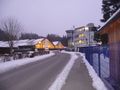
A small enterprise and some tennis halls at the edge of the village
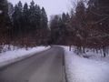
Throughout most of my expedition, I had to follow narrow streets like this one through the forest
A small part of the "quarry" near the hashpoint, it was about 50x100m large
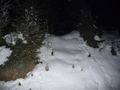
The forest was surrounded by steep terrain; between 4 and 12m in height
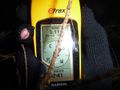
The GPS had shown a minimum distance of 2,8m to the hashpoint; it seemed like the point was on the base of a rather large tree

After panicking around in the forest, a nice Bavarian Brotzeit came in very soothing
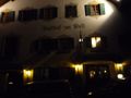
If there's one thing you can rely on in Bavaria, it's the fact that you can find a "Gasthof zur Post" ("Postal Inn") in every village

Temperature at time of arrival back at the school: -5,6°C. It didn't get above 0°C that day.


Achievements
The_T-Man earned the Displaced origin geohash achievement
|