Difference between revisions of "2008-05-24 29 -95"
From Geohashing
imported>ReletBot m (mv as per Naming conventions) |
imported>Benjw (remove redundant maps, reduce image thumbnails, remove links) |
||
| Line 10: | Line 10: | ||
The [[Houston, Texas|Houston]] location is on Bunkhouse Trail, just south of Lake Bluebonnet, in the Bar X Ranch subdivision, a few miles west of Angelton. | The [[Houston, Texas|Houston]] location is on Bunkhouse Trail, just south of Lake Bluebonnet, in the Bar X Ranch subdivision, a few miles west of Angelton. | ||
| − | + | <gallery> | |
| − | + | Image:Picresized_th_1211718844_DSC_0052.jpg|The Surrounding Landscape | |
| + | Image:Picresized_th_1211718649_DSC_0057.jpg|There was Dancing! | ||
| + | Image:picresized_th_1211718777_DSC_0060.jpg|The Houston Group | ||
| + | </gallery> | ||
| − | |||
| − | |||
| − | |||
| − | |||
| − | |||
| − | |||
| − | |||
| − | |||
| − | |||
| − | |||
| − | |||
| − | |||
| − | |||
| − | |||
| − | |||
| − | |||
| − | |||
| − | |||
[[Category:Expeditions]] | [[Category:Expeditions]] | ||
[[Category:Expeditions with photos]] | [[Category:Expeditions with photos]] | ||
[[Category:Coordinates reached]] | [[Category:Coordinates reached]] | ||
Revision as of 16:29, 8 June 2009
| Sat 24 May 2008 in Houston: 29.1266480, -95.5475331 geohashing.info google osm bing/os kml crox |
The Houston location is on Bunkhouse Trail, just south of Lake Bluebonnet, in the Bar X Ranch subdivision, a few miles west of Angelton.
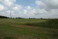
The Surrounding Landscape
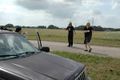
There was Dancing!

The Houston Group


