Difference between revisions of "2008-05-26 41 -93"
imported>Stretch (updating to conform with template) |
imported>Stretch (successfully updated to use template!) |
||
| Line 1: | Line 1: | ||
| − | |||
<!-- If you did not specify these parameters in the template, please substitute appropriate things for IMAGE, LAT, LON, and DATE (YYYY-MM-DD format) | <!-- If you did not specify these parameters in the template, please substitute appropriate things for IMAGE, LAT, LON, and DATE (YYYY-MM-DD format) | ||
| Line 15: | Line 14: | ||
__NOTOC__ | __NOTOC__ | ||
== Location == | == Location == | ||
| + | In a park near Ankeny, IA. | ||
| + | == Participants == | ||
| − | + | [[User:Stretch|Stretch]] | |
| + | [[User:Killamanjaro|Killamanjaro]] | ||
| − | + | [[User:vonahsen|vonahsen]] | |
== Expedition == | == Expedition == | ||
| + | |||
| + | === Stretch and Killamanjaro === | ||
| + | |||
| + | This was the first geohashing experience for [[User:Stretch|Stretch]] and [[User:Killamanjaro|Killamanjaro]]. They made a first attempt to reach the hash through a shortcut in a residential area, but after an awkward meeting with the locals who owned the fences they were attempting to climb, they were forced to go to the park entrance, far west of our destination. | ||
| + | |||
| + | They forged through a wooded area, over a creek, and emerged in a field beneath some high-voltage power lines. They did some quick mental math, converting minutes and seconds into minutes with decimals for their ancient GPS. After a little more walking and some altercations with thorn bushes and what might have been poison ivy, they arrived at the location and took pictures (around 1645 hours). | ||
| + | |||
| + | They explored the area, ate some ELFudge, and periodically shouted "XKCD! Geohashing!", attempting to meet other geohashers, but these attempts were in vain. | ||
| + | |||
| + | At long last, they hiked back to their vehicle, slightly sunburned and possibly carrying a rash. | ||
| + | |||
| + | === vonahsen === | ||
| + | |||
| + | [[User:vonahsen|vonahsen]] was there between 1550 and 1615, just missed you guys. I came from the north, through the edge of the golf course. That cart path went north all the way to the road, thanks Google maps! Some old dude came in as I was going out, probably seeing what I was up to | ||
| − | |||
== Photos == | == Photos == | ||
| − | + | <gallery perrow="4"> | |
| + | Image:Us.jpg|[[User:Killamanjaro|Killamanjaro]] (left) and [[User:Stretch|Stretch]] (right) posing at the geohash location. | ||
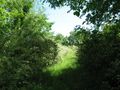
| + | Image:Location41-93.jpg|The geohashers had to trudge through field and forest as far back as the eye can see in this photograph. There was also a "No Trespassing" sign on the way. | ||
| + | Image:Gps41-93.JPG|The proof! (As close as we could approximate with our cruddy GPS, no photoshopping involved.) | ||
| + | Image:20080526_41_-93_E.jpg|More power lines | ||
| + | Image:20080526_41_-93_S.jpg|South from the hash | ||
| + | Image:20080526_41_-93_W.jpg|Totally gnarly tree west of the hash | ||
| + | </gallery> | ||
<!-- Insert pictures between the gallery tags using the following format: | <!-- Insert pictures between the gallery tags using the following format: | ||
<gallery perrow="4"> | <gallery perrow="4"> | ||
| Line 40: | Line 62: | ||
<!-- Delete the next line ONLY if you have chosen the appropriate categories below. If you are unsure, don't worry. People will read your report and help you with the classification. --> | <!-- Delete the next line ONLY if you have chosen the appropriate categories below. If you are unsure, don't worry. People will read your report and help you with the classification. --> | ||
| − | |||
<!-- Potential categories. Please include all the ones appropriate to your expedition --> | <!-- Potential categories. Please include all the ones appropriate to your expedition --> | ||
| Line 67: | Line 88: | ||
[[Category:Failed - Did not attempt]] | [[Category:Failed - Did not attempt]] | ||
--> | --> | ||
| − | |||
| − | |||
| − | |||
| − | |||
| − | |||
| − | |||
| − | |||
| − | |||
| − | |||
| − | |||
| − | |||
| − | |||
| − | |||
| − | |||
| − | |||
| − | |||
| − | |||
| − | |||
| − | |||
| − | |||
| − | |||
| − | |||
| − | |||
| − | |||
| − | |||
| − | |||
| − | |||
[[Category:Expeditions]] | [[Category:Expeditions]] | ||
[[Category:Expeditions with photos]] | [[Category:Expeditions with photos]] | ||
[[Category:Coordinates reached]] | [[Category:Coordinates reached]] | ||
Revision as of 07:50, 26 January 2010
| Mon 26 May 2008 in 41,-93: 41.6731281, -93.6073080 geohashing.info google osm bing/os kml crox |
Location
In a park near Ankeny, IA.
Participants
Expedition
Stretch and Killamanjaro
This was the first geohashing experience for Stretch and Killamanjaro. They made a first attempt to reach the hash through a shortcut in a residential area, but after an awkward meeting with the locals who owned the fences they were attempting to climb, they were forced to go to the park entrance, far west of our destination.
They forged through a wooded area, over a creek, and emerged in a field beneath some high-voltage power lines. They did some quick mental math, converting minutes and seconds into minutes with decimals for their ancient GPS. After a little more walking and some altercations with thorn bushes and what might have been poison ivy, they arrived at the location and took pictures (around 1645 hours).
They explored the area, ate some ELFudge, and periodically shouted "XKCD! Geohashing!", attempting to meet other geohashers, but these attempts were in vain.
At long last, they hiked back to their vehicle, slightly sunburned and possibly carrying a rash.
vonahsen
vonahsen was there between 1550 and 1615, just missed you guys. I came from the north, through the edge of the golf course. That cart path went north all the way to the road, thanks Google maps! Some old dude came in as I was going out, probably seeing what I was up to
Photos
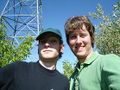
Killamanjaro (left) and Stretch (right) posing at the geohash location.
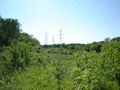
The geohashers had to trudge through field and forest as far back as the eye can see in this photograph. There was also a "No Trespassing" sign on the way.
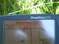
The proof! (As close as we could approximate with our cruddy GPS, no photoshopping involved.)
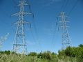
More power lines
South from the hash
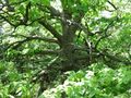
Totally gnarly tree west of the hash


