Difference between revisions of "2008-05-27 30 -97"
From Geohashing
imported>FippeBot m (Location) |
|||
| (2 intermediate revisions by 2 users not shown) | |||
| Line 1: | Line 1: | ||
{{meetup graticule | {{meetup graticule | ||
| − | |||
| lat=30 | | lat=30 | ||
| lon=-97 | | lon=-97 | ||
| date=2008-05-27 | | date=2008-05-27 | ||
}} | }} | ||
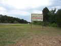
| − | + | This geohash in [[Austin, Texas]] is located on the (non-existent) shoulder of east-bound US 290 near Paige, TX. The tall grass, high-speed traffic, and the unlevel and unpaved shoulder made slowing down from 70 to 0 mph the most challenging and dangerous part of reaching this otherwise simple geohash. | |
| − | This geohash in [[Austin, Texas]] is located on the (non-existent) shoulder of east-bound US 290 near Paige, TX. The tall grass, high-speed traffic, and the unlevel and unpaved shoulder made slowing down from 70 | ||
| − | |||
| − | |||
| − | |||
| − | |||
== People == | == People == | ||
* [[User:s3g2|s3g2]] showed up around 6:15 pm. After pulling off considerably from the pavement, I took a few photos of the GPS unit and the surroundings, which were the highway and some farmland on the south side of the road. Due to the danger of the passing traffic, I did not spend long there before getting back in the car. Turning around also posed a small challenge. | * [[User:s3g2|s3g2]] showed up around 6:15 pm. After pulling off considerably from the pavement, I took a few photos of the GPS unit and the surroundings, which were the highway and some farmland on the south side of the road. Due to the danger of the passing traffic, I did not spend long there before getting back in the car. Turning around also posed a small challenge. | ||
| − | + | == Gallery == | |
| + | <gallery> | ||
Image:080527_30_-97_S.jpg|Looking south | Image:080527_30_-97_S.jpg|Looking south | ||
Image:080527_30_-97_gps089.jpg|GPS | Image:080527_30_-97_gps089.jpg|GPS | ||
| Line 21: | Line 16: | ||
Image:080527_30_-97_bm_W.jpg|Nearby | Image:080527_30_-97_bm_W.jpg|Nearby | ||
Image:080527_30_-97_bm_E.jpg|More nearby | Image:080527_30_-97_bm_E.jpg|More nearby | ||
| + | Image:080527 30 -97 s3g2.jpg|Geohasher | ||
</gallery> | </gallery> | ||
| + | |||
| + | [[Category:Expeditions]] | ||
| + | [[Category:Expeditions with photos]] | ||
| + | [[Category:Coordinates reached]] | ||
| + | {{location|US|TX|BP}} | ||
Latest revision as of 01:19, 6 August 2019
| Tue 27 May 2008 in 30,-97: 30.2096776, -97.1014417 geohashing.info google osm bing/os kml crox |
This geohash in Austin, Texas is located on the (non-existent) shoulder of east-bound US 290 near Paige, TX. The tall grass, high-speed traffic, and the unlevel and unpaved shoulder made slowing down from 70 to 0 mph the most challenging and dangerous part of reaching this otherwise simple geohash.
People
- s3g2 showed up around 6:15 pm. After pulling off considerably from the pavement, I took a few photos of the GPS unit and the surroundings, which were the highway and some farmland on the south side of the road. Due to the danger of the passing traffic, I did not spend long there before getting back in the car. Turning around also posed a small challenge.
Gallery
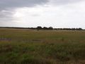
Looking south
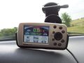
GPS
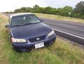
The transportation
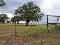
Nearby
More nearby

Geohasher


