Difference between revisions of "2008-05-27 41 -112"
From Geohashing
imported>Kaldric |
m (per Renaming Proposal) |
||
| (4 intermediate revisions by 3 users not shown) | |||
| Line 9: | Line 9: | ||
==Pictures== | ==Pictures== | ||
| − | <gallery widths="200px" perrow= | + | <gallery widths="200px" perrow=2> |
Image:Hash 5-27 009 copy.jpg | Image:Hash 5-27 009 copy.jpg | ||
Image:Hash 5-27 002 copy.jpg | Image:Hash 5-27 002 copy.jpg | ||
| Line 15: | Line 15: | ||
Image:Hash 5-27 005 copy.jpg | Image:Hash 5-27 005 copy.jpg | ||
</gallery> | </gallery> | ||
| + | |||
| + | ==Achievements== | ||
| + | {{Graticule unlocked | ||
| + | | latitude = 41 | ||
| + | | longitude = -112 | ||
| + | | date = 2008-05-27 | ||
| + | | name = [[User:Tsen|Tsen]] | ||
| + | }} | ||
| + | [[Category:Expeditions]] | ||
| + | [[Category:Expeditions with photos]] | ||
| + | [[Category:Coordinates reached]] | ||
| + | {{location|US|UT|WB}} | ||
Latest revision as of 07:42, 20 March 2024
| Tue 27 May 2008 in 41,-112: 41.2096776, -112.1014417 geohashing.info google osm bing/os kml crox |
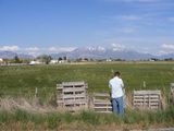
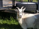
Ridiculously easy. The point is 5.24 miles from my front door. The point was in the middle of a field. Quick hop over a fence and a short walk and we were there, along with a good deal of cows, who fortunately stayed out of smelling distance. And we saw a goat. 'Bout it.
Pictures
Achievements
Tsen earned the Graticule Unlocked Achievement
|


