Difference between revisions of "2008-06-06 -27 153"
From Geohashing
(→Moreton Bay, Redland Shire, Australia) |
imported>Thomcat (Success/failure category added) |
||
| Line 1: | Line 1: | ||
| + | {{meetup graticule | ||
| + | | map=<map lat="-27" lon="153" date="2008-06-06" /> | ||
| + | | lat=-27 | ||
| + | | lon=153 | ||
| + | | date=2008-06-06 | ||
| + | | graticule_name=Brisbane | ||
| + | | graticule_link=Brisbane, Australia | ||
| + | }} | ||
| + | |||
== Moreton Bay, Redland Shire, Australia == | == Moreton Bay, Redland Shire, Australia == | ||
| Line 4: | Line 13: | ||
| − | <gallery> | + | <gallery perrow="3"> |
Image:-27-153-2008-06-06-Photo.JPG|[[User:Ubethatway|Ubethatway]] at the geohash | Image:-27-153-2008-06-06-Photo.JPG|[[User:Ubethatway|Ubethatway]] at the geohash | ||
Image:-27-153-2008-06-06-Boat.JPG|The craft | Image:-27-153-2008-06-06-Boat.JPG|The craft | ||
| Line 24: | Line 33: | ||
[[Category:Expeditions]] | [[Category:Expeditions]] | ||
[[Category:Expeditions with photos]] | [[Category:Expeditions with photos]] | ||
| − | [[Category: | + | [[Category:Coordinates reached]] |
| − | |||
Revision as of 15:11, 7 August 2008
| Fri 6 Jun 2008 in Brisbane: -27.5238146, 153.2954072 geohashing.info google osm bing/os kml crox |
Moreton Bay, Redland Shire, Australia
Ubethatway set out from the home at around 1pm with a tender for the water geohash location in Moreton Bay, just of Cleveland Point in the Redland Shire. It was a beautiful day on the bay, and the water geohash coordinates were successfully reached.
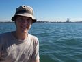
Ubethatway at the geohash
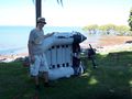
The craft
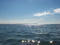
Cleveland Point from the geohash location
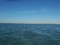
North Stradbroke and Peel Islands from the geohash location
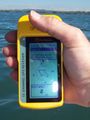
GPS coordinates of the geohash
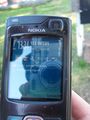
Time and date of the geohash


Participants
Achievements Earned
Ubethatway earned the Water geohash achievement
|