Difference between revisions of "2008-06-06 42 -71"
imported>Ahecht (→About) |
m (per Renaming Proposal) |
||
| (8 intermediate revisions by 5 users not shown) | |||
| Line 5: | Line 5: | ||
| date=2008-06-06 | | date=2008-06-06 | ||
}} | }} | ||
| + | |||
==About== | ==About== | ||
[http://maps.google.com/maps?q=42.759663N%2C%2071.825383W 42.759663N, 71.825383W] | [http://maps.google.com/maps?q=42.759663N%2C%2071.825383W 42.759663N, 71.825383W] | ||
| − | This hash is located in New Ipswich, NH near the Greenville border in the [[ | + | |
| + | This hash is located in New Ipswich, NH near the Greenville border in the [[Boston, Massachusetts]] graticule across the Souhegan River from Rte 123. | ||
| + | |||
| + | |||
| + | {{land geohash | ||
| + | | latitude = 42 | ||
| + | | longitude = -71 | ||
| + | | date = 2008-06-06 | ||
| + | | image = Snap-C473188F.png | ||
| + | | name = [[User:Ahecht|AHecht]] | ||
| + | }} | ||
| + | |||
| + | {{one with nature | ||
| + | | latitude = 42 | ||
| + | | longitude = -71 | ||
| + | | date = 2008-06-06 | ||
| + | | image = Downedtree.jpg | ||
| + | | name = [[User:Ahecht|AHecht]] | ||
| + | }} | ||
==Expeditions== | ==Expeditions== | ||
| + | |||
===[[User:Ahecht|AHecht]] 1:15pm EDT=== | ===[[User:Ahecht|AHecht]] 1:15pm EDT=== | ||
| + | |||
See story in gallery below. | See story in gallery below. | ||
| + | |||
<gallery caption="GeoSquishing" widths="200px" heights="200px" perrow="3"> | <gallery caption="GeoSquishing" widths="200px" heights="200px" perrow="3"> | ||
| − | Image:GMaps.Geohash.06-06-2008.Boston.jpg|These coordinates are 15 minutes from my office. I didn't find out the coordinates until I was already at work, so I had to make | + | Image:GMaps.Geohash.06-06-2008.Boston.jpg|These coordinates are 15 minutes from my office. I didn't find out the coordinates until I was already at work, so I had to make do with what I had with me. I didn't have a camera or separate GPS, so I had to use my phone as a camera and GPS unit (using a bluetooth GPS radio). I put on my emergency rain pants and waterproof boots from my car and headed out. The easiest access to the hashpoint was through a backyard that was nicely mowed all the way to the river. However, not wanting to trespass, I bushwacked my way down to the banks of the Souhegan. |
Image:Rivercrossing.jpg|After getting to the river, this is what I was faced with. I was able to get half-way across without any trouble, but the water was too deep to get across the second half dry. After walking up and down the shore, trying to find a better crossing, I decided to go for it and wade in. My waterproof boots quickly became filled with water, and of course the water wouldn't drain out. | Image:Rivercrossing.jpg|After getting to the river, this is what I was faced with. I was able to get half-way across without any trouble, but the water was too deep to get across the second half dry. After walking up and down the shore, trying to find a better crossing, I decided to go for it and wade in. My waterproof boots quickly became filled with water, and of course the water wouldn't drain out. | ||
| Line 24: | Line 46: | ||
Image:Geohash.06-06-2008.Boston.jpg|The geohash itself was in this nice little clearing. | Image:Geohash.06-06-2008.Boston.jpg|The geohash itself was in this nice little clearing. | ||
| − | Image:AHechtAt06062008Geohash.jpg|Here I am at the hash. It was just me and the | + | Image:AHechtAt06062008Geohash.jpg|Here I am at the hash. It was just me and the mosquitoes. |
Image:Marker.jpg|I had made up a stone before leaving work with the coordinates and date on it that I could leave as a marker. Yes, I know, I got the URL wrong. | Image:Marker.jpg|I had made up a stone before leaving work with the coordinates and date on it that I could leave as a marker. Yes, I know, I got the URL wrong. | ||
| Line 36: | Line 58: | ||
</gallery> | </gallery> | ||
| − | [[Category: | + | [[Category:Expeditions]] |
| − | [[Category: | + | [[Category:Expeditions with photos]] |
| + | [[Category:Coordinates reached]] | ||
| + | {{location|US|NH|HI}} | ||
Latest revision as of 14:48, 2 April 2024
| Fri 6 Jun 2008 in 42,-71: 42.7596630, -71.8253824 geohashing.info google osm bing/os kml crox |
About
This hash is located in New Ipswich, NH near the Greenville border in the Boston, Massachusetts graticule across the Souhegan River from Rte 123.
AHecht earned the Land geohash achievement
|
AHecht earned the One with Nature Geohash Achievement
|
Expeditions
AHecht 1:15pm EDT
See story in gallery below.
- GeoSquishing

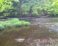
These coordinates are 15 minutes from my office. I didn't find out the coordinates until I was already at work, so I had to make do with what I had with me. I didn't have a camera or separate GPS, so I had to use my phone as a camera and GPS unit (using a bluetooth GPS radio). I put on my emergency rain pants and waterproof boots from my car and headed out. The easiest access to the hashpoint was through a backyard that was nicely mowed all the way to the river. However, not wanting to trespass, I bushwacked my way down to the banks of the Souhegan.
After getting to the river, this is what I was faced with. I was able to get half-way across without any trouble, but the water was too deep to get across the second half dry. After walking up and down the shore, trying to find a better crossing, I decided to go for it and wade in. My waterproof boots quickly became filled with water, and of course the water wouldn't drain out.
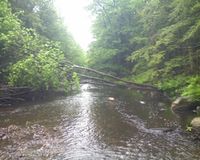
There was a downed tree crossing the river, but it looked too precarious for me to risk, especially with my GPS and phone in my pockets.
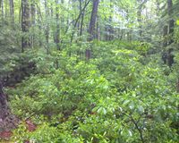
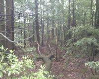
The geohash itself was in this nice little clearing.
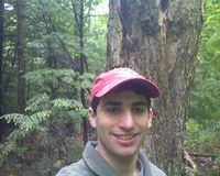
Here I am at the hash. It was just me and the mosquitoes.
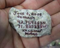
I had made up a stone before leaving work with the coordinates and date on it that I could leave as a marker. Yes, I know, I got the URL wrong.
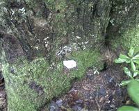
Here is the marker placed at the base of the tree closest to the coordinates.
Finally, here is the back back to the river from the geohash. Just think *squish* *squish* *squish* and you'll have a pretty good idea of what the walk back was like. After getting back the car and changing shoes, I went to the nearby Panda Wok restaurant and got pretty good chinese food for lunch.
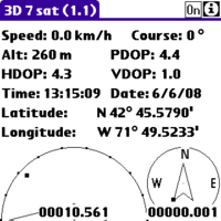
Here is the proof I reached the spot: a screenshot from the CotoGPS program running on my Palm Centro.


