Difference between revisions of "2008-06-06 51 5"
From Geohashing
imported>H.M.Thunder (→Expedition) |
m (fix, sorry) |
||
| (13 intermediate revisions by 5 users not shown) | |||
| Line 1: | Line 1: | ||
| + | {{meetup graticule | ||
| + | | map=<map lat="51" lon="5" date="2008-06-06" /> | ||
| + | | lat=51 | ||
| + | | lon=5 | ||
| + | | date=2008-06-06 | ||
| + | }} | ||
| + | |||
==About== | ==About== | ||
| + | |||
The coordinates of this geohash are | The coordinates of this geohash are | ||
<pre> | <pre> | ||
| − | 51.523814°, 5.295407° | + | 51.523814°, 5.295407° |
</pre> | </pre> | ||
| − | The hash was north of Oirschot on a field on private property. | + | |
| + | The hash was north of Oirschot on a field on private property. | ||
| + | |||
| + | [{{egl|2008-06-06|51|5|text=map}}] | ||
==Expedition== | ==Expedition== | ||
| − | [[User:H.M.Thunder|H.M.Thunder]] (Evie and Sjoerd) | + | |
| + | [[User:H.M.Thunder|H.M.Thunder]] (Evie and Sjoerd) jumped on their bike when the sun started shining. They stopped at the [http://en.wikipedia.org/wiki/De_Koningshoeven_Brewery La Trappe Abbey] for a coffee. In Moergestel they were passed by Guus Moonen who is [http://www.blikopnieuws.nl/bericht/75616 cycling 10.000 km ] in 20 days around this village. After 90 minutes (23 km) they arrived at [http://maps.google.nl/maps?q=51.523814%C2%B0,+5.295407%C2%B0&lr=lang_nl&ie=UTF8&z=16&iwloc=addr 51.523814°, 5.295407°]. A nice field with some cows in it. After a pick nick and a photo session they cycled back home. Feeling good after this successful [[Bicycle_Geohash]]. | ||
| + | |||
| + | <gallery caption="Pictures" widths="200px" heights="200px" perrow="3"> | ||
| + | Image:080606_GeoHashing_Spoordonk_Evie.JPG|Evie pointing to the third cow who is right at location of the day. | ||
| + | Image:080606_GeoHashing_Spoordonk_Sjoerd.JPG|Sjoerd from the opposite direction. | ||
| + | Image:SjoerdPickNick.JPG080606_GeoHashing_Spoordonk_SjoerdPickNick.JPG|Sjoerd with some bicycle and picknick evidence. | ||
| + | </gallery> | ||
| + | |||
| + | [[Category:Expeditions]] | ||
| + | [[Category:Expeditions with photos]] | ||
| + | [[Category:Coordinates reached]] | ||
| + | {{location|NL|NB}} | ||
Latest revision as of 18:49, 18 January 2022
| Fri 6 Jun 2008 in 51,5: 51.5238146, 5.2954072 geohashing.info google osm bing/os kml crox |
About
The coordinates of this geohash are
51.523814°, 5.295407°
The hash was north of Oirschot on a field on private property.
[map]
Expedition
H.M.Thunder (Evie and Sjoerd) jumped on their bike when the sun started shining. They stopped at the La Trappe Abbey for a coffee. In Moergestel they were passed by Guus Moonen who is cycling 10.000 km in 20 days around this village. After 90 minutes (23 km) they arrived at 51.523814°, 5.295407°. A nice field with some cows in it. After a pick nick and a photo session they cycled back home. Feeling good after this successful Bicycle_Geohash.
- Pictures
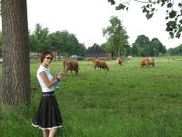
Evie pointing to the third cow who is right at location of the day.
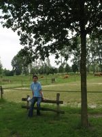
Sjoerd from the opposite direction.
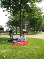
Sjoerd with some bicycle and picknick evidence.


