Difference between revisions of "2008-06-14 -34 139"
From Geohashing
imported>Karcean (New page: {{meetup graticule | map=<map lat="-34" lon="139" date="2008-06-14" /> | lat=-34 | lon=139 | date=2008-06-12 }} == About == Saturday's geohash for north eastern [[Adelaide, Australia|Adel...) |
m (More specific location) |
||
| (4 intermediate revisions by 4 users not shown) | |||
| Line 3: | Line 3: | ||
| lat=-34 | | lat=-34 | ||
| lon=139 | | lon=139 | ||
| − | | date=2008-06- | + | | date=2008-06-14 |
}} | }} | ||
== About == | == About == | ||
| − | Saturday's geohash for | + | This Saturday's geohash for the [[Mannum, Australia|Mannum Graticule]] was S34°48.4047', E139°2.3332' |
The exact location is underneath the branches of a tree as shown in the photos below. | The exact location is underneath the branches of a tree as shown in the photos below. | ||
| Line 24: | Line 24: | ||
[[Category:Expeditions]] | [[Category:Expeditions]] | ||
[[Category:Expeditions with photos]] | [[Category:Expeditions with photos]] | ||
| + | [[Category:Coordinates reached]] | ||
| + | {{location|AU|SA|BA}} | ||
Latest revision as of 11:21, 1 August 2020
| Sat 14 Jun 2008 in -34,139: -34.8067463, 139.0388869 geohashing.info google osm bing/os kml crox |
About
This Saturday's geohash for the Mannum Graticule was S34°48.4047', E139°2.3332'
The exact location is underneath the branches of a tree as shown in the photos below.
People
One group (around 3 pm) turned up
- Nathan and BobTheFish
Photos
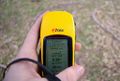
Proof that we're right there. Considering that the GPS has an estimated accuracy of 4 m I guess 0.38 m to destination isn't too bad
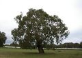
Destination is under the boughs to the left of the tree pictured
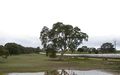
Destination tree is in the background to the left of the image


