Difference between revisions of "2008-06-20 26 -80"
imported>Aperfectring (→Aperfectring) |
Aperfectring (talk | contribs) m (→About) |
||
| (6 intermediate revisions by 5 users not shown) | |||
| Line 16: | Line 16: | ||
I plan to arrive at the parking lot near the suggested alternative location at about 7PM. I then plan to hike from there to the hash point, as long as it is not storming. | I plan to arrive at the parking lot near the suggested alternative location at about 7PM. I then plan to hike from there to the hash point, as long as it is not storming. | ||
| − | I arrived at the nature area parking lot shortly before 7PM, and waited to see if anyone else was going to join me. No one did, so I set off on my ~1.5mi hike to the geohashing site. Unfortunately about 0.4mi from the I encountered a creek which I was unprepared to cross. Therefore I turned back and went for my car. When I got back to my car, the "ranger" was preparing to close things up, so I did not have time for any pictures of how horrendous I looked after my hike through hot humid Florida evening air. | + | I arrived at the nature area parking lot shortly before 7PM, and waited to see if anyone else was going to join me. No one did, so I set off on my ~1.5mi hike to the geohashing site. Unfortunately about 0.4mi from the I encountered a creek which I was unprepared to cross. Therefore I turned back and went for my car. When I got back to my car, the "ranger" was preparing to close things up, so I did not have time for any pictures of how horrendous I looked after my hike through hot humid Florida evening air. However, it was absolutely beautiful in that nature area, and the beginning of the sunset was brilliant to watch as I made my retreat back to my car. |
<gallery> | <gallery> | ||
| − | + | Image:2008_06_20_aperfectring_1.JPG | The nature area near the 2008_06_20 26 -80 geohash. | |
| + | Image:2008_06_20_aperfectring_2.JPG | More of the nature area near the 2008_06_20 26 -80 geohash. | ||
| + | Image:2008_06_20_aperfectring_3.JPG | A barrier is blocking my path! | ||
| + | Image:2008_06_20_aperfectring_4.JPG | Phew, at least I can walk in. | ||
| + | Image:2008_06_20_aperfectring_5.JPG | The road on the way to the geohash. | ||
| + | Image:2008_06_20_aperfectring_6.JPG | The end of the road and maybe alligators. | ||
</gallery> | </gallery> | ||
[[Category:Expeditions]] | [[Category:Expeditions]] | ||
| + | [[Category:Expeditions with photos]] | ||
| + | [[Category:Coordinates not reached]] | ||
| + | [[Category:Not reached - Mother Nature]] | ||
| + | {{location|US|FL|PL}} | ||
Latest revision as of 23:41, 8 February 2020
| Fri 20 Jun 2008 in 26,-80: 26.8663951, -80.2270141 geohashing.info google osm bing/os kml crox |
About
Just off of FL 701 (Bee Line Hwy) near the North Palm Beach County Airport.
Expeditions
Aperfectring
I plan to arrive at the parking lot near the suggested alternative location at about 7PM. I then plan to hike from there to the hash point, as long as it is not storming.
I arrived at the nature area parking lot shortly before 7PM, and waited to see if anyone else was going to join me. No one did, so I set off on my ~1.5mi hike to the geohashing site. Unfortunately about 0.4mi from the I encountered a creek which I was unprepared to cross. Therefore I turned back and went for my car. When I got back to my car, the "ranger" was preparing to close things up, so I did not have time for any pictures of how horrendous I looked after my hike through hot humid Florida evening air. However, it was absolutely beautiful in that nature area, and the beginning of the sunset was brilliant to watch as I made my retreat back to my car.
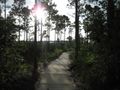
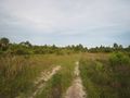
The nature area near the 2008_06_20 26 -80 geohash.
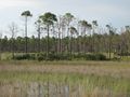
More of the nature area near the 2008_06_20 26 -80 geohash.
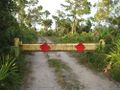
A barrier is blocking my path!
Phew, at least I can walk in.
The road on the way to the geohash.
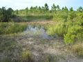
The end of the road and maybe alligators.


