Difference between revisions of "2008-06-21 55 13"
imported>HannesL (→Meetup #1) |
imported>FippeBot m (Location) |
||
| (7 intermediate revisions by 4 users not shown) | |||
| Line 7: | Line 7: | ||
==About== | ==About== | ||
| − | <b>[http://kartor.eniro.se/query?&what=map_adr&mop=aq&searchInMap=1&mapstate=7;13.613962;55.979317;a This hash]</b> in the [[Malmö, Sweden|Malmö, Sweden graticule]] was located north of Höör. This time in what could be most easily be descibed as a swamp. | + | <b>[http://kartor.eniro.se/query?&what=map_adr&mop=aq&searchInMap=1&mapstate=7;13.613962;55.979317;a This hash]</b> in the [[Malmö, Sweden|Malmö, Sweden graticule]] was located north of Höör. This time in what could be most easily be descibed as a swamp. |
| − | + | <p> | |
| + | Two teams reached the point. Team one was on time and came the closest. Team two was late (17.00) and too lazy to get out of the car... Team two were quite close. | ||
| + | </p> | ||
GPS: (55.979317N, 13.613962E). | GPS: (55.979317N, 13.613962E). | ||
==Meetup #1== | ==Meetup #1== | ||
| − | [[user:Karl-Anders|Karl-Anders]] drove there accompanied by Ernst and Ida. | + | [[user:Karl-Anders|Karl-Anders]] drove there accompanied by [[user:Ernst|Ernst]] and Ida. Due to a very poor choice of shoes we couldn't get to the exact spot, but the first photo is of the general area of the spot. |
| Line 30: | Line 32: | ||
Image:2008-06-21_55_13_6.jpg|Therese in the shootgun position. | Image:2008-06-21_55_13_6.jpg|Therese in the shootgun position. | ||
</gallery> | </gallery> | ||
| + | |||
| + | [[Category:Expeditions]] | ||
| + | [[Category:Expeditions with photos]] | ||
| + | [[Category:Coordinates not reached]] | ||
| + | [[Category:Not reached - Mother Nature]] | ||
| + | {{location|SE|M}} | ||
Latest revision as of 05:21, 7 August 2019
| Sat 21 Jun 2008 in 55,13: 55.9793177, 13.6139621 geohashing.info google osm bing/os kml crox |
About
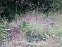
This hash in the Malmö, Sweden graticule was located north of Höör. This time in what could be most easily be descibed as a swamp.
Two teams reached the point. Team one was on time and came the closest. Team two was late (17.00) and too lazy to get out of the car... Team two were quite close.
GPS: (55.979317N, 13.613962E).
Meetup #1
Karl-Anders drove there accompanied by Ernst and Ida. Due to a very poor choice of shoes we couldn't get to the exact spot, but the first photo is of the general area of the spot.
- Photo Gallery
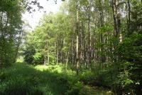
The spot, somewhere straight ahead.
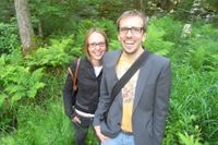
Ernst and Ida.

Ernst (again!) and K-A with map and GPS.


Meetup #2
David, HannesL and Therese drove to the spot. Was there about an hour after the first team. The last piece of road looked to narrow for the Geohash-mobile, so we chickened out. Good that someone made an honest attempt to find the exact location. I guess we're to lazy. See you guys the next time!
- Photo Gallery
No wheat field this time.
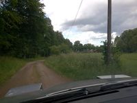
Here we should have made a 160 degree turn left onto a very small gravel road.
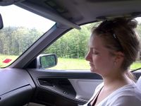
Therese in the shootgun position.


