Difference between revisions of "2008-07-05 49 -122"
From Geohashing
imported>Queerasmoi |
imported>Queerasmoi |
||
| Line 13: | Line 13: | ||
== Photographic Evidence == | == Photographic Evidence == | ||
| − | <gallery widths="150px" heights=" | + | <gallery widths="150px" heights="150px" perrow="2"> |
Image:2008-07-05-gps-surrey.jpg|GPS reading from the on-time expedition | Image:2008-07-05-gps-surrey.jpg|GPS reading from the on-time expedition | ||
Image:Reduced-DSCN7267.JPG|[[User:Queerasmoi|Queerasmoi]], [[User:Garyuuko|Garyuuko]], Jeremy and [[User:Jakke|Jakke]] | Image:Reduced-DSCN7267.JPG|[[User:Queerasmoi|Queerasmoi]], [[User:Garyuuko|Garyuuko]], Jeremy and [[User:Jakke|Jakke]] | ||
Image:2008-07-05_49_-122.JPG|[[User:Robyn|Robyn]]'s bike at the hashpoint. | Image:2008-07-05_49_-122.JPG|[[User:Robyn|Robyn]]'s bike at the hashpoint. | ||
</gallery> | </gallery> | ||
Revision as of 05:22, 6 July 2008
| Sat 5 Jul 2008 in 49,-122: 49.1489437, -122.9212957 geohashing.info google osm bing/os kml crox |
I reached the point on time along with 3 other hashers and got photos, but I am utterly confused with how image posting and category tags work. Sorry. :( Maybe I will try again later. Queerasmoi 04:39, 6 July 2008 (UTC)
Rain and muddy bike paths and poor signs on bridges notwithstanding I achieved the hashpoint forty-five minutes late. But I got it done. I was hoping to meet someone at last, but my slow cycling and getting lost on Anacis Island trying to find out how to get onto the Alex Fraser Bridge made me a lonely hasher. Robyn 04:28, 6 July 2008 (UTC)
Full story at my blog.
Photographic Evidence
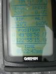
GPS reading from the on-time expedition
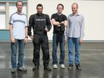
Queerasmoi, Garyuuko, Jeremy and Jakke
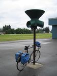
Robyn's bike at the hashpoint.


