Difference between revisions of "2008-07-30 53 8"
m (per Renaming Proposal) |
|||
| (4 intermediate revisions by one other user not shown) | |||
| Line 1: | Line 1: | ||
| − | + | {{meetup graticule | |
| − | |||
| − | |||
| − | |||
| − | |||
| − | |||
| − | |||
| − | |||
| − | |||
| lat={{#explode:{{SUBPAGENAME}}| |1}} | | lat={{#explode:{{SUBPAGENAME}}| |1}} | ||
| lon={{#explode:{{SUBPAGENAME}}| |2}} | | lon={{#explode:{{SUBPAGENAME}}| |2}} | ||
| date={{#explode:{{SUBPAGENAME}}| |0}} | | date={{#explode:{{SUBPAGENAME}}| |0}} | ||
| − | }} | + | }} |
__NOTOC__ | __NOTOC__ | ||
== Location == | == Location == | ||
| − | + | ||
| + | The hash was located in the yard of an apartment building in the northern part of Oldenburg, Germany. | ||
== Participants == | == Participants == | ||
| − | + | ||
| − | + | [[User:Alaska|Alaska]] | |
== Plans == | == Plans == | ||
| − | |||
| − | |||
| − | |||
| − | |||
| − | |||
| − | |||
| − | |||
| − | + | Yes, it took me almost twelve years! Here's why: | |
| − | |||
| − | |||
| − | |||
| − | |||
| − | |||
| − | + | This was going to be my first Geohash, back in 2008, just a few weeks after Randall had published his Geohashing webcomic. I had been eagerly waiting for a hash location near Oldenburg where I was (and still am) living. And ''this'' turned out to be the first real good opportunity for a Geohashing expedition. | |
| − | |||
| − | |||
| − | + | Unfortunately, it also turned out that the plan to document the expedition was a little harder to execute than the trip itself. In the days and weeks after, I simply didn't find the time or wasn't in the mood to transfer the photos from my (good old Nokia N95) phone and to write some expedition report. And then – I probably just forgot about it. | |
| − | |||
| − | |||
| − | + | Until September 2018, when fellow Geohasher [[User:Fippe]] surprisingly contacted me, asking if I could finally document the expedition, mainly because it was the first one in its graticule and as such of some “historic importance”. I answered him that I would try to find the old photos and to provide the report. Which – you guess it! – was again a little harder than expected because due to a computer crash in 2009 or 2010, I lost access to most of my older photos. I remember searching for the expedition photos, but unfortunately without success. And then – I probably just forgot about it again. | |
| − | + | Until a few days ago (i.e. end of June 2020), when I found an old hard drive, connected it to my PC, browsed through its contents, and – badaboom! – discovered the long missed photos in some obscurely nested backup folder! So finally, after almost twelve years, I'm able to provide the report on my first Geohashing expedition! And sorry, the expedition report itself is much less exceptional than its release story ... | |
| − | |||
| − | |||
| − | |||
| − | + | ''(Is there an achievement for the longest time period between going on an expedition and documenting it?)'' | |
| − | + | == Expedition == | |
| − | |||
| − | |||
| − | |||
| − | |||
| − | |||
| − | |||
| − | |||
| − | |||
| − | |||
| + | After work, I took the bike and went to the hash location, arriving there around 6 pm local time. No one else was there, so I left a note with “xkcd” written on it on a nearby tree stump, just in case someone else would show up later. Took some photos (including a self-timer one of myself with my bike), made a screenshot of my phone's GPS location, and left again. | ||
| − | + | == Photos == | |
| − | |||
| − | |||
| − | |||
| − | |||
| − | |||
| − | |||
| − | |||
| − | + | <gallery perrow="5"> | |
| − | + | Image:20080730618.jpg | The hash location is somewhere on this yard. | |
| − | + | Image:20080730621.jpg | Does that count as a stupid grin? | |
| − | + | Image:20080730622.jpg | I hope the person who found it at least googled it ... | |
| − | + | Image:Screenshot0004.jpg | Screenshot of the phone's GPS location | |
| + | Image:Screenshot0006.jpg | Screenshot of the phone's map | ||
| + | </gallery> | ||
| − | + | == Achievements == | |
| − | {{ | + | {{#vardefine:ribbonwidth|800px}} |
| − | | | + | {{land geohash | latitude = 53 | longitude = 8 | date = 2008-07-30 | name = Alaska | image = 20080730621.jpg }} |
| − | | | + | {{Bicycle geohash | latitude = 53 | longitude = 8 | date = 2008-07-30 | name = Alaska | distance = 7.1 km/5.2 km | bothways = true | image = 20080730621.jpg }} |
| − | | date=2008-07-30 | + | {{Graticule unlocked | latitude = 53 | longitude = 8 | date = 2008-07-30 | name = Alaska | image = 20080730621.jpg }} |
| − | | | + | {{Two to the N achievement | count = 0 | latitude = 53 | longitude = 8 | date = 2008-07-30 | name = Alaska | image = 20080730621.jpg }} |
| − | | | ||
| − | }} | ||
[[Category:Expeditions]] | [[Category:Expeditions]] | ||
| + | [[Category:Expeditions with photos]] | ||
[[Category:Coordinates reached]] | [[Category:Coordinates reached]] | ||
{{location|DE|NI|OL|city=true}} | {{location|DE|NI|OL|city=true}} | ||
Latest revision as of 07:38, 20 March 2024
| Wed 30 Jul 2008 in 53,8: 53.1701131, 8.2305790 geohashing.info google osm bing/os kml crox |
Location
The hash was located in the yard of an apartment building in the northern part of Oldenburg, Germany.
Participants
Plans
Yes, it took me almost twelve years! Here's why:
This was going to be my first Geohash, back in 2008, just a few weeks after Randall had published his Geohashing webcomic. I had been eagerly waiting for a hash location near Oldenburg where I was (and still am) living. And this turned out to be the first real good opportunity for a Geohashing expedition.
Unfortunately, it also turned out that the plan to document the expedition was a little harder to execute than the trip itself. In the days and weeks after, I simply didn't find the time or wasn't in the mood to transfer the photos from my (good old Nokia N95) phone and to write some expedition report. And then – I probably just forgot about it.
Until September 2018, when fellow Geohasher User:Fippe surprisingly contacted me, asking if I could finally document the expedition, mainly because it was the first one in its graticule and as such of some “historic importance”. I answered him that I would try to find the old photos and to provide the report. Which – you guess it! – was again a little harder than expected because due to a computer crash in 2009 or 2010, I lost access to most of my older photos. I remember searching for the expedition photos, but unfortunately without success. And then – I probably just forgot about it again.
Until a few days ago (i.e. end of June 2020), when I found an old hard drive, connected it to my PC, browsed through its contents, and – badaboom! – discovered the long missed photos in some obscurely nested backup folder! So finally, after almost twelve years, I'm able to provide the report on my first Geohashing expedition! And sorry, the expedition report itself is much less exceptional than its release story ...
(Is there an achievement for the longest time period between going on an expedition and documenting it?)
Expedition
After work, I took the bike and went to the hash location, arriving there around 6 pm local time. No one else was there, so I left a note with “xkcd” written on it on a nearby tree stump, just in case someone else would show up later. Took some photos (including a self-timer one of myself with my bike), made a screenshot of my phone's GPS location, and left again.
Photos
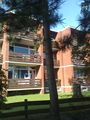
The hash location is somewhere on this yard.
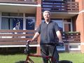
Does that count as a stupid grin?
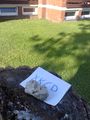
I hope the person who found it at least googled it ...
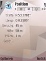
Screenshot of the phone's GPS location
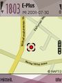
Screenshot of the phone's map


Achievements
Alaska earned the Land geohash achievement
|
Alaska earned the Bicycle geohash achievement
|
Alaska earned the Graticule Unlocked Achievement
|
