Difference between revisions of "2008-08-09 49 -123"
From Geohashing
imported>Thepiguy (Does anyone even read these?) |
m (More specific location) |
||
| (3 intermediate revisions by 3 users not shown) | |||
| Line 8: | Line 8: | ||
==Details== | ==Details== | ||
| − | I 410'd it to the mall then 404'd it to Ladner Trunk road and found a little path that lead me straight to the hash point. I waited around until the designated hour, hoping that at the last second a large team of covert ninja geohashers would jump out of the bushes to join me. When this didn't happen, I hung out in the nearby park for a half hour and went home when it started to rain. | + | I 410'd it to the mall then 404'd it to Ladner Trunk road and found a little path that lead me straight to the hash point. I waited around until the designated hour, hoping that at the last second a large team of covert [[Ninja Geohasher|ninja geohashers]] would jump out of the bushes to join me. When this didn't happen, I hung out in the nearby park for a half hour and went home when it started to rain. |
<gallery widths="150px" heights="100px" perrow="2"> | <gallery widths="150px" heights="100px" perrow="2"> | ||
| Line 16: | Line 16: | ||
Image:2008-08-09 49 -123 camp.jpg|I set up base camp and settled in. | Image:2008-08-09 49 -123 camp.jpg|I set up base camp and settled in. | ||
</gallery> | </gallery> | ||
| + | |||
| + | [[Category:Expeditions]] | ||
| + | [[Category:Expeditions with photos]] | ||
| + | [[Category:Coordinates reached]] | ||
| + | {{location|CA|BC|MV}} | ||
Latest revision as of 22:39, 9 August 2020
| Sat 9 Aug 2008 in 49,-123: 49.0913829, -123.0585948 geohashing.info google osm bing/os kml crox |
Thepiguy was there. Where were you?
Details
I 410'd it to the mall then 404'd it to Ladner Trunk road and found a little path that lead me straight to the hash point. I waited around until the designated hour, hoping that at the last second a large team of covert ninja geohashers would jump out of the bushes to join me. When this didn't happen, I hung out in the nearby park for a half hour and went home when it started to rain.
That 1 second of longitude puts you in someones yard.

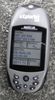
Geohasher: A self portrait.
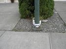
Location was tagged in order to confuse locals.
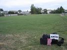
I set up base camp and settled in.


