Difference between revisions of "2008-08-09 49 12"
From Geohashing
imported>Dawidi m (Categories etc.) |
imported>Thomcat (Success/failure category added) |
||
| Line 19: | Line 19: | ||
Image:2008-08-09 49 12 schwaighausen-gpses.jpg|Three GPSes that can't quite agree on their location... | Image:2008-08-09 49 12 schwaighausen-gpses.jpg|Three GPSes that can't quite agree on their location... | ||
</gallery> | </gallery> | ||
| + | |||
[[Category:Expeditions]] | [[Category:Expeditions]] | ||
[[Category:Expeditions with photos]] | [[Category:Expeditions with photos]] | ||
| + | [[Category:Coordinates reached]] | ||
Revision as of 15:09, 13 August 2008
| Sat 9 Aug 2008 in Regensburg, Germany: 49.0913829, 12.0585948 geohashing.info google osm bing/os kml crox |
The spot was directly on a track in a forest between Schwaighausen and Hainsacker, north of Regensburg.
Dawidi and a fellow geocacher (who goes by the username Tomcat93) went there by bike, nommed some cake and candy, waited for 16:00 to pass by, took pictures and left.
There was some sort of a hiking festival going on, the last 2 km to the hash were filled with elderly pedestrians wearing t-shirts advertising various non-local hiking clubs, but they passed about 40m east of the hash. A fire brigade truck went by too, maybe for picking up exhausted hikers?
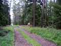
View from the hash - just your basic average forest.
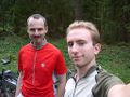
Tomcat93 (left) and dawidi at the coordinates.

Three GPSes that can't quite agree on their location...


