Difference between revisions of "2008-08-09 50 -119"
From Geohashing
imported>Juventas |
m (More specific location) |
||
| (4 intermediate revisions by 4 users not shown) | |||
| Line 8: | Line 8: | ||
}} | }} | ||
| − | [[user:Juventas | Juventas]] traveled south of Lavington to the Aberdeen Lake forestry service road. After driving 24km of gravel road he headed eastward on a recreational off-roading trail and stopped after about 1km. He proceeded on the trail by foot for about 250m until encountering swamp surrounding one of the | + | [[user:Juventas | Juventas]] traveled south of Lavington to the Aberdeen Lake forestry service road. After driving 24km of gravel road he headed eastward on a recreational off-roading trail and stopped after about 1km. He proceeded on the trail by foot for about 250m until encountering swamp surrounding one of the Specs Lakes. With a storm rolling in, he decided not to continue, but captured a picture 200m from the coordinates. The coordinates can be clearly seen in the gap in the trees, 20m from the shoreline. |
| Line 14: | Line 14: | ||
<gallery perrow="2"> | <gallery perrow="2"> | ||
Image:2008-08-09_end_of_road.jpg | Time to get out on foot | Image:2008-08-09_end_of_road.jpg | Time to get out on foot | ||
| − | Image:2008-08-09_spec_lake.jpg | One of the | + | Image:2008-08-09_spec_lake.jpg | One of the Specs Lakes |
Image:2008-08-09_valley.jpg | Some scenery on the way back | Image:2008-08-09_valley.jpg | Some scenery on the way back | ||
</gallery> | </gallery> | ||
| Line 20: | Line 20: | ||
[[Category:Expeditions]] | [[Category:Expeditions]] | ||
[[Category:Expeditions with photos]] | [[Category:Expeditions with photos]] | ||
| − | [[Category:Coordinates reached]] | + | [[Category:Coordinates not reached]] |
| + | [[Category:Not reached - Mother Nature]] | ||
| + | {{location|CA|BC|NO}} | ||
Latest revision as of 22:39, 9 August 2020
| Sat 9 Aug 2008 in Vernon, British Columbia: 50.0913829, -119.0585948 geohashing.info google osm bing/os kml crox |
Juventas traveled south of Lavington to the Aberdeen Lake forestry service road. After driving 24km of gravel road he headed eastward on a recreational off-roading trail and stopped after about 1km. He proceeded on the trail by foot for about 250m until encountering swamp surrounding one of the Specs Lakes. With a storm rolling in, he decided not to continue, but captured a picture 200m from the coordinates. The coordinates can be clearly seen in the gap in the trees, 20m from the shoreline.
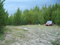
Time to get out on foot
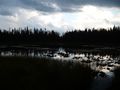
One of the Specs Lakes
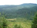
Some scenery on the way back


