Difference between revisions of "2008-08-16 53 12"
From Geohashing
imported>ReletBot m (Failed => Not reached) |
imported>ReletBot m (Automatically appending gallery for one of relet's expeditions.) |
||
| Line 24: | Line 24: | ||
[[Category:Coordinates not reached]] | [[Category:Coordinates not reached]] | ||
[[Category:Not reached - Mother Nature]] | [[Category:Not reached - Mother Nature]] | ||
| + | |||
| + | == Gallery == | ||
| + | <gallery widths="160px" align=center> | ||
| + | Image:200808165312-P1010901.JPG|Left side of pasture. | ||
| + | Image:200808165312-P1010902.JPG|Right side. | ||
| + | Image:200808165312-P1010903.JPG|Nearby. | ||
| + | Image:200808165312-P1010904.JPG|Coordinates. | ||
| + | </gallery> | ||
Revision as of 16:45, 30 June 2009

| Sat 16 Aug 2008 in Müritz: 53.3351359, 12.6121764 geohashing.info google osm bing/os kml crox |
| Expedition map - Stops: Brandenburg, Magdeburg, Braunschweig, Hannover, Hamburg (West), Hamburg (East), Schwerin, Müritz, Uckermark |
The expedition (8)
This one was located next to a small village in the Müritz landscape. The village was accessible via a narrow single lane paved road. As it turned out, the hash lay in a sheep pasture right at the edge of the village - this one actually featuring sheep. As he had had his share of adventures, and would not want to scare the sheep in circles, relet decided to stay on the road. He took some photos from the hash from afar, and from the readings of his GPS and drove on.
Photos
Gallery
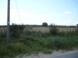
Left side of pasture.
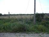
Right side.
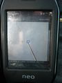
Nearby.
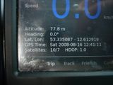
Coordinates.


