Difference between revisions of "2008-08-17 55 -115"
imported>Robyn (So close.) |
m (per Renaming Proposal) |
||
| (10 intermediate revisions by 5 users not shown) | |||
| Line 1: | Line 1: | ||
{{meetup graticule | {{meetup graticule | ||
| − | | map=<map lat="55" lon="- | + | | map=<map lat="55" lon="-115" date="2008-08-17" /> |
| lat=55 | | lat=55 | ||
| − | | lon=- | + | | lon=-115 |
| − | | date=2008-08- | + | | date=2008-08-17 |
}} | }} | ||
==Location== | ==Location== | ||
| − | This | + | This hash was 21 kilometres from home, within five kilometres of the highway, about a kilometre past the end of an access road. The satellite image shows a dirt-coloured road connecting slightly wider dirt-coloured patches, so utility access most likely, and the hashpoint itself lies in dark green vegetation. |
| + | |||
| + | ==Participants== | ||
| + | [[User:Robyn|Robyn]] and her $100 Wal-Mart bicycle, with the front inner tube newly mended. | ||
==Planning== | ==Planning== | ||
| − | + | Once again I marked up my map with detailed lat-long coordinates of every bend in the road, in case there were unknown sideroads to choose from. I repaired the hole in the inner tube from yesterday, took the wheel across the street to the Shell to inflate the tire, and when it was still holding air by the time I crossed back and installed it on the bicycle, I declared it sound. | |
| + | |||
| + | ==Expedition== | ||
| + | Riding west on Highway 2 was delightfully easy, despite the knowledge that the wind at my back would be full in my face on the homeward journey. Hence I was glad of an uphill grade for two reasons: one because it would make coming home easier and two because the higher up I went, the less chance there would be a swamp like [[2008-08-16 55 -114|yesterday]]. It took the calculated 45 minutes of riding to reach the turnoff. | ||
| − | + | The turnoff was an excellent dirt road that passed a house, then a number of "Danger High Voltage" and "Danger Underground Pipeline" type substations in little cages, and ended in another little utility shack. It was lovely really, with grass and trees all around, and "merely" 0.55 nm from the geohash. I set off into the bush. | |
| − | |||
| − | + | First I climbed a bank of grass and thistles and berry bushes, stopping to eat all the berries I could find. In fact I kept meaning to photograph the berries, but I never seemed to get my camera out before I had eaten them. My theory was that if I ate all the berries so there was none left, the bears would have no reason to frequent this neck of the woods. Entering the forest itself, I suddenly realized my compass was not around my neck. I had left it next to the computer, for some reason. That makes navigation in forest a little tricker, as I expect to lose the GPS signal in here. I'll try to go in a straight line. | |
| − | |||
| − | + | It's hard to go in any line here. It's not as dense as BC coastal forest, but that means that things grow on the forest floor, as opposed to them being dark and passable. Every step I took was on a multi-layered obstacle course of fallen trees spiked with sharp dead branches, grasses, young trees, uprooted stumps, holes and other hazards. Literally every step has to be calculated and tested. There are a lot of fallen trees here, and the way they lie they are all not quite high enough to go under, but a little too high to easily go over. So I have to either go around, or go over with difficulty. I can't go ten steps in a straight line without having to go over or around something. I get out my chalk and start marking arrows on trees and logs, pointing back the way I came, in case the GPS dies or I can't regain signal. There is a far off honking sound that I imagine to be animals, which I hope are herbivores, communicating with one another over long distances. Then I realize the sound is coming from my own backpack. It's bizarre to have cellphone reception in such a remote-seeming place. | |
| − | The | + | The GPS keeps getting confused about its orientation, telling me I'm going 180 degrees or 90 degrees off track. It's not designed for hiking and is confused by swinging from my wrist as I climb over trees, I think. I use the techniques I learned in girl guides for progressing in a straight line in the woods, and the GPS sorts itself out to agree with me. I also mark GPS waypoints all along my route. I'm progressing at a rate of about 0.01 nm in five minutes. There are little scratches all over my legs, and the back of my hand is bleeding, the blood feathering in with the sweat to make a nice pattern. I hope there are no land sharks here. |
| − | + | I know there are not land sharks, but there are bears. I saw bear scat yesterday and my co-workers reported seeing a bear with blond streaks right by the side of the road. I try to console myself with the speculation that a ''bear'' would be smarter than to try to get through these woods, and also I wouldn't have to worry about making a decision about running away or playing dead if I encountered one. There's no WAY I could run in here. But maybe I shouldn't have eaten all the berries. Now the bears will have nothing left to eat but me. My "you're doing something stupid" alarm is screaming at me. I have progressed 0.17 nm since I left the bicycle. In about an hour. That would mean two more hours to destination. And three more back. I put the GPS down on a log and photograph it before turning back. I know what I am now. I am Mother Nature's Bitch. | |
| − | + | {{done with nature | |
| + | | latitude = 55 | ||
| + | | longitude = -115 | ||
| + | | date = 2008-08-17 | ||
| + | | name = Robyn | ||
| + | | image = 2008-08-17.FaceofDefeat.JPG | ||
| + | }} | ||
| + | Moments later, the low battery alarm went on my GPS. I have brought spare batteries, but what if they don't work? What if I drop one and can't find it in the forest? What if my knapsack has already been ripped open and I've lost them? I fight my way out of the woods. It's a little easier than going forward, probably just because of the angle of the light, and not because there is any sentient motive on the part of the forest to prevent me from reaching my goal. By way of small victory, I get out of the woods (although without seeing a single chalk mark that I made) and fought my way back home on the bike against the wind. | ||
==Photo Gallery== | ==Photo Gallery== | ||
<gallery> | <gallery> | ||
| − | Image:2008-08- | + | Image:2008-08-17.Sunbeams.JPG|The forest lurks in wait. |
| − | Image:2008-08- | + | Image:2008-08-17.DenseBrush.JPG|Typical view of the forest ahead of me. |
| − | Image:2008-08- | + | Image:2008-08-17.ClosestApproach.JPG|My "stupid" alarm rang loudly enough to turn me back here. |
| − | Image:2008-08- | + | Image:2008-08-17.FaceofDefeat.JPG|Acknowledging my defeat at the hands of Mother Nature. |
| + | |||
</gallery> | </gallery> | ||
| − | [[Category:Expeditions]][[Category:Meetup on 2008-08- | + | |
| + | [[Category:Expeditions]] | ||
| + | [[Category:Meetup on 2008-08-17]] | ||
| + | [[Category:Meetup in 55 -115]] | ||
| + | [[Category:Coordinates not reached]] | ||
| + | [[Category:Not reached - Mother Nature]] | ||
| + | [[Category:Expeditions with photos]] | ||
| + | {{location|CA|AB|LS}} | ||
Latest revision as of 14:46, 2 April 2024
| Sun 17 Aug 2008 in 55,-115: 55.3047357, -115.0104490 geohashing.info google osm bing/os kml crox |
Location
This hash was 21 kilometres from home, within five kilometres of the highway, about a kilometre past the end of an access road. The satellite image shows a dirt-coloured road connecting slightly wider dirt-coloured patches, so utility access most likely, and the hashpoint itself lies in dark green vegetation.
Participants
Robyn and her $100 Wal-Mart bicycle, with the front inner tube newly mended.
Planning
Once again I marked up my map with detailed lat-long coordinates of every bend in the road, in case there were unknown sideroads to choose from. I repaired the hole in the inner tube from yesterday, took the wheel across the street to the Shell to inflate the tire, and when it was still holding air by the time I crossed back and installed it on the bicycle, I declared it sound.
Expedition
Riding west on Highway 2 was delightfully easy, despite the knowledge that the wind at my back would be full in my face on the homeward journey. Hence I was glad of an uphill grade for two reasons: one because it would make coming home easier and two because the higher up I went, the less chance there would be a swamp like yesterday. It took the calculated 45 minutes of riding to reach the turnoff.
The turnoff was an excellent dirt road that passed a house, then a number of "Danger High Voltage" and "Danger Underground Pipeline" type substations in little cages, and ended in another little utility shack. It was lovely really, with grass and trees all around, and "merely" 0.55 nm from the geohash. I set off into the bush.
First I climbed a bank of grass and thistles and berry bushes, stopping to eat all the berries I could find. In fact I kept meaning to photograph the berries, but I never seemed to get my camera out before I had eaten them. My theory was that if I ate all the berries so there was none left, the bears would have no reason to frequent this neck of the woods. Entering the forest itself, I suddenly realized my compass was not around my neck. I had left it next to the computer, for some reason. That makes navigation in forest a little tricker, as I expect to lose the GPS signal in here. I'll try to go in a straight line.
It's hard to go in any line here. It's not as dense as BC coastal forest, but that means that things grow on the forest floor, as opposed to them being dark and passable. Every step I took was on a multi-layered obstacle course of fallen trees spiked with sharp dead branches, grasses, young trees, uprooted stumps, holes and other hazards. Literally every step has to be calculated and tested. There are a lot of fallen trees here, and the way they lie they are all not quite high enough to go under, but a little too high to easily go over. So I have to either go around, or go over with difficulty. I can't go ten steps in a straight line without having to go over or around something. I get out my chalk and start marking arrows on trees and logs, pointing back the way I came, in case the GPS dies or I can't regain signal. There is a far off honking sound that I imagine to be animals, which I hope are herbivores, communicating with one another over long distances. Then I realize the sound is coming from my own backpack. It's bizarre to have cellphone reception in such a remote-seeming place.
The GPS keeps getting confused about its orientation, telling me I'm going 180 degrees or 90 degrees off track. It's not designed for hiking and is confused by swinging from my wrist as I climb over trees, I think. I use the techniques I learned in girl guides for progressing in a straight line in the woods, and the GPS sorts itself out to agree with me. I also mark GPS waypoints all along my route. I'm progressing at a rate of about 0.01 nm in five minutes. There are little scratches all over my legs, and the back of my hand is bleeding, the blood feathering in with the sweat to make a nice pattern. I hope there are no land sharks here.
I know there are not land sharks, but there are bears. I saw bear scat yesterday and my co-workers reported seeing a bear with blond streaks right by the side of the road. I try to console myself with the speculation that a bear would be smarter than to try to get through these woods, and also I wouldn't have to worry about making a decision about running away or playing dead if I encountered one. There's no WAY I could run in here. But maybe I shouldn't have eaten all the berries. Now the bears will have nothing left to eat but me. My "you're doing something stupid" alarm is screaming at me. I have progressed 0.17 nm since I left the bicycle. In about an hour. That would mean two more hours to destination. And three more back. I put the GPS down on a log and photograph it before turning back. I know what I am now. I am Mother Nature's Bitch.
Robyn earned the Done with Nature consolation prize
|
Moments later, the low battery alarm went on my GPS. I have brought spare batteries, but what if they don't work? What if I drop one and can't find it in the forest? What if my knapsack has already been ripped open and I've lost them? I fight my way out of the woods. It's a little easier than going forward, probably just because of the angle of the light, and not because there is any sentient motive on the part of the forest to prevent me from reaching my goal. By way of small victory, I get out of the woods (although without seeing a single chalk mark that I made) and fought my way back home on the bike against the wind.
Photo Gallery
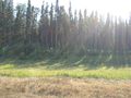
The forest lurks in wait.
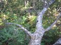
Typical view of the forest ahead of me.
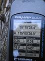
My "stupid" alarm rang loudly enough to turn me back here.

Acknowledging my defeat at the hands of Mother Nature.


