Difference between revisions of "2008-08-19 49 -123"
imported>Thepiguy (Damn spell check) |
imported>Thepiguy (Photos added.) |
||
| Line 27: | Line 27: | ||
==Images== | ==Images== | ||
| − | + | <gallery widths="150px" heights="100px" perrow="4"> | |
| + | Image:2008-08-19 49 -123 oval.jpg|I got to bike by Richmond's speed skating oval. | ||
| + | Image:2008-08-19 49 -123 hash.jpg|Here is the hash point. Riveting, isn't it? | ||
| + | Image:2008-08-19 49 -123 gps.jpg|I should make a gallery that is just gps close ups... | ||
| + | Image:2008-08-19 49 -123 me.jpg|No time for fancy photography this time! | ||
| + | Image:2008-08-19 49 -123 bike.jpg|Ding ding! | ||
| + | Image:2008-08-19 49 -123 berries.jpg|Breakfast? | ||
| + | Image:02008-08-19 49 -123 firsthash.jpg|A picture of my [[2008-05-27 49 -123]] geohash! It was my very first! | ||
| + | Image:2008-08-19 49 -123 srs.jpg|[[user:srs0|srs0]] didn't mind that I was late for work. I'm sure he'll mind that I posted this though... | ||
| + | </gallery> | ||
[[Category:Expeditions]] | [[Category:Expeditions]] | ||
[[Category:Expeditions with photos]] | [[Category:Expeditions with photos]] | ||
[[Category:Coordinates reached]] | [[Category:Coordinates reached]] | ||
Revision as of 22:00, 19 August 2008
| Tue 19 Aug 2008 in 49,-123: 49.2016628, -123.0496741 geohashing.info google osm bing/os kml crox |
Thepiguy made his fourth geohash expedition in four days! This time it was only a 45km bike ride on his way to work and by far his most spontaneous hash yet!
Details
Since the weather forecast said it was going to rain today, and I still haven't gotten fenders for my new bike, I had decided the night before that I was going to bus to work instead of taking my bike. Since I didn't have to bike, I accidentally slept in and was already running when I decided, on a whim, to check the day's coordinates.
At first I thought there was a mistake, "It's in the city? Again? How could that be!" And then, once I realized it was indeed true; "Awwww crap. I am going to be sooo late for work."
I grabbed every piece of biking gear in site and stuffed it into my panniers, along with a hastily made lunch, my GPS, and my camera (which still contained the pictures from the previous nights geohash). I emailed my coworker to let him know I was going to be late and set out on my bike.
I was partially familiar with the area, but as for how to get there on a bike; I had no clue. I took the dike as far as I could, and then ended up cycling east on Bridgeport. As bad as I thought Bridgeport was for cycling, it was nothing compared to River Road; narrow road, steep gravel shoulder complete with ditch and semi-trucks passing you in both directions!
The hash point was located in a parking lot of what I believe to be a tow truck company. I only spent a few minutes there. I took a couple of pictures, dropped my GPs on the pavement, stole some blackberries off of a nearby bus and set off to work.
Thinking my excitement was done for the day I decided to take the Knight Street bridge into Vancouver and just follow SW Marine Drive all the way to UBC: nice and simple, what could possible go wrong? Well, apparently, the Knight Street bridge doesn't just go to Vancouver, it makes a small stop along the way. This is where things went wrong.
Although the sign did inform me I was taking the "Mitchell Road" exit, nowhere did it say that Mitchell Road was actually on Mitchell Island! It's a good thing I decided to check my GPS, because I had no idea I was not in Vancouver. Although, I guess even if I hadn't checked, I would have found out anyway... it's not that big of an island.
When I finally got in to Vancouver (the real Vancouver this time!) I made my way as planned, down SW Marine. I even passed by my very first geohash! It was located on the roof-top parking lot of a Superstore. I would have stopped by to check it out again, but I was running late enough already and just admired it from across the street.
I finally made it to work, only and hour and 15 minutes late!
Images
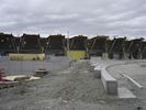
I got to bike by Richmond's speed skating oval.
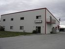
Here is the hash point. Riveting, isn't it?
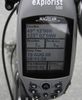
I should make a gallery that is just gps close ups...

No time for fancy photography this time!
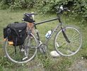
Ding ding!
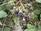
Breakfast?
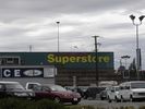
A picture of my 2008-05-27 49 -123 geohash! It was my very first!
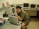
srs0 didn't mind that I was late for work. I'm sure he'll mind that I posted this though...


