Difference between revisions of "2008-09-13 52 11"
From Geohashing
imported>Relet (→Photos: -) |
imported>FippeBot m (Location) |
||
| Line 41: | Line 41: | ||
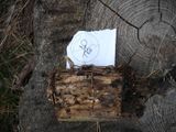
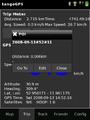
Image:200809135211-Screenshot-5.png|The proof. | Image:200809135211-Screenshot-5.png|The proof. | ||
</gallery> | </gallery> | ||
| + | {{location|DE|BB|PR}} | ||
Latest revision as of 06:58, 7 August 2019

| Sat 13 Sep 2008 in 52,11: 52.9503779, 11.9611570 geohashing.info google osm bing/os kml crox |
Participants
Plans
To work.. oh, you know.
Expedition
Arriving in Bad Wilsnack, it was just a short 10 minutes ride to the hash point. A little too short almost, as relet managed to overshoot its goal by a good distance. He backtraced to a small forest track leading him close to the hash, then went cross country to the hash. He decided that a tree stump would do as a landmark.
He took the usual photos, and, noticing that he still had a few hash marks left from his last multihash, left a hashmark on the tree. Satisfied, he went on a bike tour round the Prignitz region, again collecting some geocaches on the way. He managed to miss the other confluence cache though.
Tracklog
Gallery
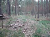
The track.
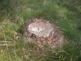
The stump.

The grin.
The hash.
Some cache.
The proof.


