Difference between revisions of "2008-09-29 49 11"
imported>Dawidi (New page: {{meetup graticule | map=<map lat="49" lon="11" date="2008-09-29" /> | lat=49 | lon=11 | date=2008-09-29 | graticule_name=Nuremberg, Germany | graticule_link=Nuremberg, Germany }} ==[[Use...) |
m (per Renaming Proposal) |
||
| (9 intermediate revisions by 4 users not shown) | |||
| Line 8: | Line 8: | ||
}} | }} | ||
| − | ==[[User:dawidi|dawidi]]== | + | ==[[User:dawidi|dawidi]] and [[User:Tomcat|Tomcat]] == |
Today we performed an "inverse drag-along", for lack of a better achievement to call it by. | Today we performed an "inverse drag-along", for lack of a better achievement to call it by. | ||
| − | The hashpoint happened to be very close to my friend Tomcat's home (he | + | The hashpoint happened to be very close to my friend [[User:Tomcat|Tomcat]]'s home (he was not yet registered at the time) in Eilsbrunn, and it's a long uphill ride for me to get there from Regensburg. He cycled to the hashpoint first, then rode downhill and met me at around two thirds of the way, after which we went to the coordinates again and arrived around sunset. |
The exact point was in a currently unused (and dry!) field, so this time it was reachable and GPS reception was fine. | The exact point was in a currently unused (and dry!) field, so this time it was reachable and GPS reception was fine. | ||
| Line 20: | Line 20: | ||
Image:2008-09-29 49 11 eilsbrunn-gpsloc.jpg|Within 60cm of the hash. The GPS fix just drifted away a bit while I was bending over it to take the picture... srsly! | Image:2008-09-29 49 11 eilsbrunn-gpsloc.jpg|Within 60cm of the hash. The GPS fix just drifted away a bit while I was bending over it to take the picture... srsly! | ||
Image:2008-09-29 49 11 eilsbrunn-north.jpg|Looking north from the hash. | Image:2008-09-29 49 11 eilsbrunn-north.jpg|Looking north from the hash. | ||
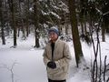
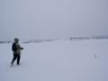
| − | Image:2008-09-29 49 11 eilsbrunn-south.jpg|Looking south from the hash. Tomcat and [[User:dawidi|dawidi]]. | + | Image:2008-09-29 49 11 eilsbrunn-south.jpg|Looking south from the hash. [[User:Tomcat|Tomcat]] and [[User:dawidi|dawidi]]. |
</gallery> | </gallery> | ||
| + | |||
| + | ==Déjà vu!== | ||
| + | I just found proof (not perfect, but acceptable, I hope) for achieving the [[Déjà Vu Geohash]] there - I was there on 2003-02-02 with my dad! (The images have only been downsampled with IrfanView, leaving the EXIF tag intact.) | ||
| + | <gallery> | ||
| + | Image:2003-02-02 49 11 eilsbrunn-dejavu-73.JPG|EXIF time 11:00, me in the forest just east of the point. | ||
| + | Image:2003-02-02 49 11 eilsbrunn-dejavu-78.JPG|EXIF time 11:10, view to the hashpoint from the nearest track. | ||
| + | Image:2003-02-02 49 11 eilsbrunn-dejavu-82.JPG|EXIF time 11:12, at less than 50m from the hash. The perspective is the same as in the self-portrait from the 2008 visit (compare the house). | ||
| + | Image:2003-02-02 49 11 eilsbrunn-dejavu-83.JPG|EXIF time 11:13, my dad stomping away through the snow. | ||
| + | Image:2003-02-02 49 11 eilsbrunn-dejavu-85.JPG|Zoomed view of the same forest edge as in the 2008 north view. | ||
| + | </gallery> | ||
| + | |||
| + | {{Déjà vu geohash | ||
| + | | latitude = 49 | ||
| + | | longitude = 11 | ||
| + | | date = 2008-09-29 | ||
| + | | olddate = 2003-02-02 | ||
| + | | name = [[User:Dawidi|dawidi]] | ||
| + | | image = 2003-02-02 49 11 eilsbrunn-dejavu-73.JPG | ||
| + | }} | ||
| + | |||
| + | {{couch potato geohash | latitude = 49 | longitude = 11 | date = 2008-09-29 | name = Tomcat | honor = true | image = 2008-09-29 49 11 eilsbrunn-south.jpg}} | ||
| + | |||
| + | {{Graticule unlocked | latitude = 49 | longitude = 11 | date = 2008-09-29 | ||
| + | | name = dawidi and Tomcat | image = 2008-09-29 49 11 eilsbrunn-south.jpg }} | ||
[[Category:Expeditions]] | [[Category:Expeditions]] | ||
[[Category:Expeditions with photos]] | [[Category:Expeditions with photos]] | ||
[[Category:Coordinates reached]] | [[Category:Coordinates reached]] | ||
| + | {{location|DE|BY|R}} | ||
Latest revision as of 07:34, 20 March 2024
| Mon 29 Sep 2008 in Nuremberg, Germany: 49.0066368, 11.9874894 geohashing.info google osm bing/os kml crox |
dawidi and Tomcat
Today we performed an "inverse drag-along", for lack of a better achievement to call it by.
The hashpoint happened to be very close to my friend Tomcat's home (he was not yet registered at the time) in Eilsbrunn, and it's a long uphill ride for me to get there from Regensburg. He cycled to the hashpoint first, then rode downhill and met me at around two thirds of the way, after which we went to the coordinates again and arrived around sunset.
The exact point was in a currently unused (and dry!) field, so this time it was reachable and GPS reception was fine.
It was about to get dark, so we just took a few quick pictures and left.
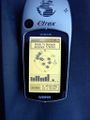
Within 60cm of the hash. The GPS fix just drifted away a bit while I was bending over it to take the picture... srsly!
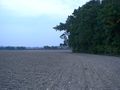
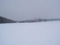
Looking north from the hash.


Déjà vu!
I just found proof (not perfect, but acceptable, I hope) for achieving the Déjà Vu Geohash there - I was there on 2003-02-02 with my dad! (The images have only been downsampled with IrfanView, leaving the EXIF tag intact.)
EXIF time 11:00, me in the forest just east of the point.
EXIF time 11:10, view to the hashpoint from the nearest track.
EXIF time 11:12, at less than 50m from the hash. The perspective is the same as in the self-portrait from the 2008 visit (compare the house).
EXIF time 11:13, my dad stomping away through the snow.
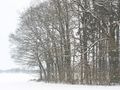
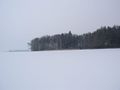
Zoomed view of the same forest edge as in the 2008 north view.


dawidi earned the Déjà Vu Geohash Achievement
|

dawidi and Tomcat earned the Graticule Unlocked Achievement
|