Difference between revisions of "2008-10-04 53 6"
imported>Arvid (gallery added.) |
imported>Arvid (there will be MOAR, still 18:00-05:00 to cover.) |
||
| Line 20: | Line 20: | ||
*[[Bicycle Geohash|Cycled]] 339.4km. | *[[Bicycle Geohash|Cycled]] 339.4km. | ||
*[[XKCD-100]] by bicycle! | *[[XKCD-100]] by bicycle! | ||
| − | * He did cross the border, but that wasn't strictly a necessary part of the trip. Although it was definitely shorter. | + | *[[Multihash]], visited 2 hashes on one day. |
| + | * He did cross the [[Border geohash|border]], but that wasn't strictly a necessary part of the trip. Although it was definitely shorter. | ||
==Expedition== | ==Expedition== | ||
| − | [http://maps.google.com/maps?f=q&hl=en&geocode=&q=http:%2F%2Farvid.org%2Ftracks%2Fgeohash20081004.kmz Tracklog] | + | [http://maps.google.com/maps?f=q&hl=en&geocode=&q=http:%2F%2Farvid.org%2Ftracks%2Fgeohash20081004.kmz Tracklog] |
| + | |||
| + | I left home around 8am, first going to the ATM, for when all else would fail. I made a picture of the sun rising there, and at 8:10 I was really off. | ||
| + | I was planning to do around 20km/h total average, so I was supposed to be at the hash at 16:00. | ||
| − | |||
First I went to the 52 6 hash, which was nearly on the route to 53 6 anyway. In the morning it was sunny and cold. | First I went to the 52 6 hash, which was nearly on the route to 53 6 anyway. In the morning it was sunny and cold. | ||
| − | Around 9:30 I | + | Around 9:30 I arrived the 52 6 hash, which was in a tree-zone between two ditches. It wasn't very easy to access, but I made it, and around 9:45 I was on my way again. Stats so far: 31.2km, avg 23.0km/h, avg cadence 100, max 33.5km/h |
| + | |||
| + | I did want to stop as little as possible, because standing still is worse than cycling slowly. Altough only 15 minutes later I had to stop again to take my jacket off, and replace my yellow lenses for the dark ones. At 10:10 I entered Germany, but the quality of the border picture is bad, also because at the border the bike lane changes from one side of the road to the other, for no apparent reason, but it does mean 2 sharp turns and watching out carefully. | ||
| + | |||
| + | At 11:00 I was in Emlichheim, where it was 8°C. Which is colder than my own coldest geohash, but no match for the current record. I also took a wrong turn at that exact location, I found out later. Luckily my GPS has maps, so I just took an alternative route. Just before the border there were some yes-knodders. I only expected those later, but these were the only ones. At 11:20 I was entering the Netherlands again, where there were some roadworks. Well, nothing was happening of course, since it was saturday. At noon I was in Emmen, and I decided to go on cycling as long as I could before stopping again. | ||
| + | |||
| + | Around 14:20 I was in Hoogezand, where there was some cycling event going on. It was very busy, with a road shut down and it being saturday. At 15:00 it was time for a stop again, just before crossing the canal in the direction of Ten Post. Around 15:45 I saw a church clock in 't Zandt with the time. And since I wanted a 4pm hash, I tried a bit harder from there on, although I had no idea how far the hash still was. | ||
| + | |||
| + | At 16:04 I was at the point on the road only 30m from the hash. I say that counts as a 4pm meetup, although no one else was there. At 16:10 was at the hashpoint, in a harvested cornfield, from the looks of it. The ground was very muddy, sticky, and clay-like. It was cold and windy, and there was no shelter at all, so at 16:15 I left the hashpoint again. Stats until then: 172.9km, avg 23.6km/h, avg cadence 99, max 45.6km/h (there was a hill in Germany). | ||
| + | |||
| + | Under the highway fly-over nearby I had something to eat&drink, after the hashpoint itself. And now the fun could really start, the wind had gotten stronger, and it was probably all headwind from now on. From the GPS-logs I can see my speed just after the hash was around 15-20km/h, where it had been around 25km/h earlier. | ||
| + | |||
| + | At 17:00, in Wirdum, fate struck. My derailleur failed. A pin had dropped out, and that messed up the alignment completely since something was loose now, that shouldn't be. I was able to find back the pin, amazing enough. A couple of houses earlier I heard workshop noises, so I walked back a bit. But a man living one house next to where I stopped asked if he could help. Well... yes! He helped. The pin is still in. I made a picture of him, told him what I was doing and about my plans. I also told him I'll log this, but told him http://xkcd.com/geohashing. A couple of kms further I realized that should've been http://wiki.xkcd.com/geohashing . I hope he finds it anyway, I think of sending him a postcard with the correct link. | ||
| + | |||
| + | Of course this fixing cost a lot of time. I got back on my way at 17:45. | ||
| + | |||
| + | |||
| + | |||
| + | |||
| Line 62: | Line 83: | ||
[[Category:Expeditions with photos]] | [[Category:Expeditions with photos]] | ||
[[Category:Coordinates reached]] | [[Category:Coordinates reached]] | ||
| − | |||
| − | |||
| − | |||
| − | |||
Revision as of 15:30, 5 October 2008
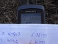
| Sat 4 Oct 2008 in 53,6: 53.4091331, 6.7639894 geohashing.info google osm bing/os kml crox |
| Sat 4 Oct 2008 in 52,6: 52.4091331, 6.7639894 geohashing.info google osm bing/os kml crox |
Plan
Arvid is getting ready for his XKCD-100. Will also do the 52 6 hash in the morning first. There will be northwestern wind on the way to the hash, and southwestern wind on the way back. That's 2 times headwind, and in the evening wind will be up to 9Bft(usually probably around 6). This should've been a reason not to go, but anyway, I'm still alive.
Achievements
- Cycled 339.4km.
- XKCD-100 by bicycle!
- Multihash, visited 2 hashes on one day.
- He did cross the border, but that wasn't strictly a necessary part of the trip. Although it was definitely shorter.
Expedition
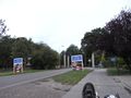
I left home around 8am, first going to the ATM, for when all else would fail. I made a picture of the sun rising there, and at 8:10 I was really off. I was planning to do around 20km/h total average, so I was supposed to be at the hash at 16:00.
First I went to the 52 6 hash, which was nearly on the route to 53 6 anyway. In the morning it was sunny and cold. Around 9:30 I arrived the 52 6 hash, which was in a tree-zone between two ditches. It wasn't very easy to access, but I made it, and around 9:45 I was on my way again. Stats so far: 31.2km, avg 23.0km/h, avg cadence 100, max 33.5km/h
I did want to stop as little as possible, because standing still is worse than cycling slowly. Altough only 15 minutes later I had to stop again to take my jacket off, and replace my yellow lenses for the dark ones. At 10:10 I entered Germany, but the quality of the border picture is bad, also because at the border the bike lane changes from one side of the road to the other, for no apparent reason, but it does mean 2 sharp turns and watching out carefully.
At 11:00 I was in Emlichheim, where it was 8°C. Which is colder than my own coldest geohash, but no match for the current record. I also took a wrong turn at that exact location, I found out later. Luckily my GPS has maps, so I just took an alternative route. Just before the border there were some yes-knodders. I only expected those later, but these were the only ones. At 11:20 I was entering the Netherlands again, where there were some roadworks. Well, nothing was happening of course, since it was saturday. At noon I was in Emmen, and I decided to go on cycling as long as I could before stopping again.
Around 14:20 I was in Hoogezand, where there was some cycling event going on. It was very busy, with a road shut down and it being saturday. At 15:00 it was time for a stop again, just before crossing the canal in the direction of Ten Post. Around 15:45 I saw a church clock in 't Zandt with the time. And since I wanted a 4pm hash, I tried a bit harder from there on, although I had no idea how far the hash still was.
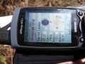
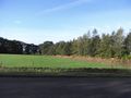
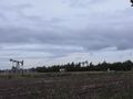
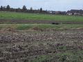
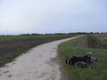
At 16:04 I was at the point on the road only 30m from the hash. I say that counts as a 4pm meetup, although no one else was there. At 16:10 was at the hashpoint, in a harvested cornfield, from the looks of it. The ground was very muddy, sticky, and clay-like. It was cold and windy, and there was no shelter at all, so at 16:15 I left the hashpoint again. Stats until then: 172.9km, avg 23.6km/h, avg cadence 99, max 45.6km/h (there was a hill in Germany).
Under the highway fly-over nearby I had something to eat&drink, after the hashpoint itself. And now the fun could really start, the wind had gotten stronger, and it was probably all headwind from now on. From the GPS-logs I can see my speed just after the hash was around 15-20km/h, where it had been around 25km/h earlier.
At 17:00, in Wirdum, fate struck. My derailleur failed. A pin had dropped out, and that messed up the alignment completely since something was loose now, that shouldn't be. I was able to find back the pin, amazing enough. A couple of houses earlier I heard workshop noises, so I walked back a bit. But a man living one house next to where I stopped asked if he could help. Well... yes! He helped. The pin is still in. I made a picture of him, told him what I was doing and about my plans. I also told him I'll log this, but told him http://xkcd.com/geohashing. A couple of kms further I realized that should've been http://wiki.xkcd.com/geohashing . I hope he finds it anyway, I think of sending him a postcard with the correct link.
Of course this fixing cost a lot of time. I got back on my way at 17:45.
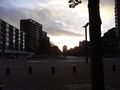
Sun coming up over Enschede.
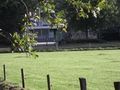
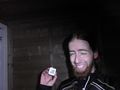
Success no1.
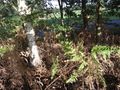
The hashpoint.
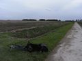
View from hashpoint to bike.
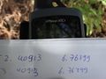
Time&date.
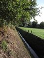
Ditch next to hashpoint, bike somewhere at the end.
View from bike to hashpoint.

Cold, but not freezing.
Yes-nodders.
Amsterdam, but new!
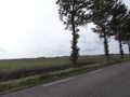
Open field.
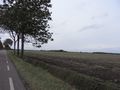
More open field. Imagine some serious wind here.
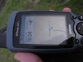
This is a 4pm hash!
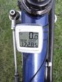
Total distance cycled to the hash.
Success no2!
View from hashpoint to bike.
View from bike to hashpoint.
View in other direction.
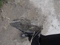
Clay/mud. Not good on clicking pedals.
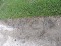
Tagging the road next to the hashpoint.

I get more useless at grinning.
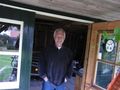
Saviour!

Home!
And the distance.


