Difference between revisions of "2008-10-13 67 20"
imported>FippeBot m (Location) |
m |
||
| Line 49: | Line 49: | ||
<gallery perrow="3"> | <gallery perrow="3"> | ||
| − | |||
| − | |||
Image:2008-10-13 67 20 3.png | Jeppzer crossing the stream | Image:2008-10-13 67 20 3.png | Jeppzer crossing the stream | ||
Image:2008-10-13 67 20 4.jpg | Sautusjärvi | Image:2008-10-13 67 20 4.jpg | Sautusjärvi | ||
| − | |||
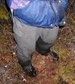
Image:2008-10-13 67 20 6.jpg | This was the closest we deemed possible within the error margin of the device | Image:2008-10-13 67 20 6.jpg | This was the closest we deemed possible within the error margin of the device | ||
| − | |||
| − | |||
| − | |||
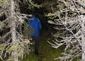
Image:2008-10-13 67 20 10.jpg | We got wet | Image:2008-10-13 67 20 10.jpg | We got wet | ||
Image:2008-10-13 67 20 11.jpg | On our way back | Image:2008-10-13 67 20 11.jpg | On our way back | ||
Revision as of 00:49, 29 November 2023
| Mon 13 Oct 2008 in Jukkasjärvi: 67.8815920, 20.7812315 geohashing.info google osm bing/os kml crox |
Our first expedition!
The hashpoint was on the northern side of the lake Sautusjärvi, near the village Jukkasjärvi, Sweden. We (the ru and Jeppzer) were anxious that we wouldn't get another chance with a feasible hash point before winter, so we decided to brave the menacing woods. We believed them to be inhabited by fierce werewolves, but failed to bring back any proof of their presence. We did however reach the hash point, celebrated with Mentos, left a sign and took some photos.
We first travelled by car from Kiruna to Jukkasjärvi. The Maanselkämaa dirt road allowed us to get almost within 2 km of the hash.
We left the car and started walking. The terrain was a mix of thick pine/spruce forest and bog, making it difficult to find a good path to follow. We alternated between ATV tracks (that were flooded in many places), animal tracks and simply stumbling randomly through the undergrowth. The water level in the lake was low, so in some areas we walked along the shore. We passed some cabins and crossed a small stream.
By the time we reached the point it was getting rather dark, so we (w)ielded flashlights for the return trip. The only other person we saw was a fisherman in a boat, that didn't seem very interested in spontaneous adventures.
The water was frozen in many places, but we were unable to bring any evidence (i.e. a thermometer) to claim a Frozen Geohash. There's no hurry, we'll have plenty of time to get one this winter.
This expedition was too easy to merit a MNIMB achievement.
the ru and Jeppzer earned the North geohash achievement
|
the ru and Jeppzer earned the Land geohash achievement
|
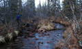
Jeppzer crossing the stream
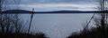
Sautusjärvi

This was the closest we deemed possible within the error margin of the device
We got wet
On our way back


