Difference between revisions of "2008-10-20 49 10"
imported>Danatar m |
imported>Danatar |
||
| Line 30: | Line 30: | ||
Image:2008-10-20_49_10_7retro200810084909.jpg|Hashpoint for 2008-10-08 49 9:Where the internet goes, it leaves marks for all time. | Image:2008-10-20_49_10_7retro200810084909.jpg|Hashpoint for 2008-10-08 49 9:Where the internet goes, it leaves marks for all time. | ||
</gallery> | </gallery> | ||
| + | |||
| + | |||
| + | ====Revisit==== | ||
| + | <gallery> | ||
| + | Image:2010-06-13_49_10_20081020.jpg|hashpoint seen from the other side of the river, [[2010-06-13_49_10|20 months later]] | ||
| + | </gallery> | ||
| + | |||
| + | |||
[[Category:Expeditions]] | [[Category:Expeditions]] | ||
Revision as of 08:56, 16 June 2010
| Mon 20 Oct 2008 in Bamberg: 49.6689202, 10.0933991 geohashing.info google osm bing/os kml crox |
Contents
Location
Today's location is on a narrow artificial piece of land next to / in the Main river. The place belongs to Ochsenfurt (in English: Oxford), directly across the Main is the town center of Frickenhausen.
Expedition
Danatar
In the morning the temperature was 2°C, but after lunch the sun came out and it was quite warm (up to 17°). As usual, I went geohashing by bike. All along the Main is a bicycle path so I just had to follow it from Würzburg to Ochsenfurt. Then I stumbled through the shrubbery on the narrow bridge of land until I was at the hashpoint. At hash o'clock I started my return trip, but stopped at the next beer garden to drink a cold 'Radler' ('cyclist' = beer + lemonade).
Later, when I passed near the 2008-10-08 49 9 hashpoint, I decided to go there again. My chalk marks were gone, but the sticks were still visible. The grape harvest was in course around me. With my bike odometer, I retraced my steps from that expedition to get the exact distance I had walked that day.
Total distance cycled: 24 km + 24.6 km = 48.6 km
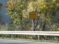
Ochsenfurt town sign, I had to take a detour for this proof.
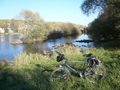
The piece of land is connected to the mainland, otherwise I would have waded through the knee-deep water.
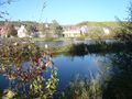
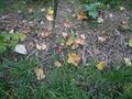
Hashpoint is somewhere here. In the background you can see Frickenhausen.

Coordinates reached

Here's to geohashing. Oechsner is a brewery in Ochsenfurt.

Oans, zwoa, gsuffa!
Hashpoint for 2008-10-08 49 9:Where the internet goes, it leaves marks for all time.


Revisit
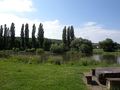
hashpoint seen from the other side of the river, 20 months later
