Difference between revisions of "2008-10-22 51 12"
From Geohashing
imported>Manu |
m (Location correction) |
||
| (4 intermediate revisions by 3 users not shown) | |||
| Line 6: | Line 6: | ||
}} | }} | ||
| − | Today's Geohashing point was located at a wet meadow near Thallwitz, where I got after work. My report | + | Today's Geohashing point was located at a wet meadow near Thallwitz, where I got after work. Unfortunately I realized too late that the rechargeable batteries of my camera had remained in the charger, so there are no photos available. On the other hand the recorded GPS track should prove that I was at the hashing point at the right date and had to climb down a precipitous slope to reach it. My detailed report about a bike trip in the rain will follow. |
---[[User:Manu|Manu]] | ---[[User:Manu|Manu]] | ||
| + | |||
| + | <gallery caption="Photo Gallery" widths="200px" heights="200px" perrow="2"> | ||
| + | Image:hashpoint1022.jpg|GPS track as kind of proof of date and location. | ||
| + | </gallery> | ||
| + | |||
| + | [[Category:Expeditions]] | ||
| + | [[Category:Coordinates reached]] | ||
| + | {{location|DE|SN|L}} | ||
Latest revision as of 19:51, 16 May 2020
| Wed 22 Oct 2008 in 51,12: 51.4256092, 12.6821185 geohashing.info google osm bing/os kml crox |
Today's Geohashing point was located at a wet meadow near Thallwitz, where I got after work. Unfortunately I realized too late that the rechargeable batteries of my camera had remained in the charger, so there are no photos available. On the other hand the recorded GPS track should prove that I was at the hashing point at the right date and had to climb down a precipitous slope to reach it. My detailed report about a bike trip in the rain will follow.
---Manu
- Photo Gallery
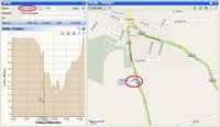
GPS track as kind of proof of date and location.
