Difference between revisions of "2008-11-08 43 -72"
imported>Ctta0s (New page: {{subst:Expedition |image = filename |lat = 43 |lon = -72 |date = 2008-11-08 }} {{meetup graticule | map=<map lat="43" lon="-72" date="2008-11-08" /> | lat=43 | lon=-72 | date=2008-11-08 ...) |
imported>FippeBot m (Location) |
||
| (3 intermediate revisions by one other user not shown) | |||
| Line 1: | Line 1: | ||
| + | [[Image:2008_11_08_43_-72_woods_view.JPG|thumb|left]] | ||
| − | |||
| − | |||
| − | |||
| − | |||
| − | |||
| − | |||
| − | |||
| − | |||
| − | |||
| − | |||
| − | |||
| − | |||
| − | |||
| − | |||
| − | |||
| − | |||
| − | |||
| − | |||
| − | |||
| − | |||
| − | |||
| − | |||
| − | |||
| − | |||
| − | |||
| − | |||
| − | |||
| − | |||
| − | |||
| − | |||
| − | |||
| − | |||
| − | |||
| − | |||
[[Category:Expeditions]] | [[Category:Expeditions]] | ||
[[Category:Expeditions with photos]] | [[Category:Expeditions with photos]] | ||
| − | |||
| − | |||
| − | |||
[[Category:Coordinates reached]] | [[Category:Coordinates reached]] | ||
| − | |||
| − | |||
| − | |||
| − | |||
| − | |||
| − | |||
| − | |||
| − | |||
{{meetup graticule | {{meetup graticule | ||
| Line 56: | Line 12: | ||
| graticule_name=Claremont | | graticule_name=Claremont | ||
| graticule_link=Claremont, New Hampshire}} | | graticule_link=Claremont, New Hampshire}} | ||
| − | |||
| − | |||
| − | |||
== About == | == About == | ||
| − | Some (swampy) woods in New Hampshire about an hour northeast of Keene. | + | Some (swampy) woods in New Hampshire about an hour northeast of Keene. Not too far off the road. |
== Expeditions == | == Expeditions == | ||
===Dartmouth Expedition=== | ===Dartmouth Expedition=== | ||
A small contingent from Dartmouth drove down to the hash. Originally planned to have more people, but timing/rain nixed that plan. The group consisted of: | A small contingent from Dartmouth drove down to the hash. Originally planned to have more people, but timing/rain nixed that plan. The group consisted of: | ||
| − | [[User:Ctta0s|Michael]], Nicole, Randall, Rosemary, and Scout. We drove in on a dirt road and got pretty close (within .5 miles or so). Unfortunately, turning around was a bit tricky. Luckily, Scout was skilled enough (and perhaps more importantly, patient enough) to execute the many-pointed turn necessary to get us back on the road. | + | [[User:Ctta0s|Michael]], Nicole, [[User:Xkcd|Randall]], Rosemary, and Scout. We drove in on a dirt road and got pretty close (within .5 miles or so). Unfortunately, turning around was a bit tricky. Luckily, Scout was skilled enough (and perhaps more importantly, patient enough) to execute the many-pointed turn necessary to get us back on the road. |
| − | We hiked a bit up the road and then struck out into the woods at Randall's direction. We quickly came upon a couple abandoned beaver dams! We proceeded across one of the dams and continued up a slight into a more rocky area. After a few minutes, we realized we had been drifting a bit to the right (possibly because it was not as steep). We corrected course and soon came to the coordinates at the base of a hill. We then took a group picture (to be uploaded soon | + | We hiked a bit up the road and then struck out into the woods at Randall's direction. We quickly came upon a couple abandoned beaver dams! We proceeded across one of the dams and continued up a slight incline into a more rocky area. After a few minutes, we realized we had been drifting a bit to the right (possibly because it was not as steep). We corrected course and soon came to the coordinates at the base of a hill. We then took a group picture (to be uploaded soon™) and finally headed back out to the road for the trip home (which involved mind-straining games such as Green Glass Door, John's Dark Tunnel, and Contact!). |
More pictures to come... | More pictures to come... | ||
| Line 74: | Line 27: | ||
Image:2008_11_08_43_-72_car_turnaround.JPG|Making a "100-point turn" to get out of the mud! | Image:2008_11_08_43_-72_car_turnaround.JPG|Making a "100-point turn" to get out of the mud! | ||
Image:2008_11_08_43_-72_woods_view.JPG|The woods. It's actually a bit swampish. | Image:2008_11_08_43_-72_woods_view.JPG|The woods. It's actually a bit swampish. | ||
| − | Image:2008_11_08_43_-72_beaver_dam. | + | Image:2008_11_08_43_-72_beaver_dam.JPG|A beaver dam! |
| − | Image:2008_11_08_43_-72_rock_king. | + | Image:2008_11_08_43_-72_rock_king.JPG|King of the rock? |
| − | Image:2008_11_08_43_-72_checking_coords. | + | Image:2008_11_08_43_-72_checking_coords.JPG|Randall checks our position. |
| − | Image:2008_11_08_43_-72_gps. | + | Image:2008_11_08_43_-72_gps.JPG|We made it! Sorry it's blurry! |
| − | Image:2008_11_08_43_-72_scout_tripod. | + | Image:2008_11_08_43_-72_scout_tripod.JPG|Scout sets up the tripod. |
</gallery> | </gallery> | ||
| + | {{location|US|NH|CH}} | ||
Latest revision as of 00:41, 8 August 2019

| Sat 8 Nov 2008 in Claremont: 43.1282440, -72.0973623 geohashing.info google osm bing/os kml crox |
About
Some (swampy) woods in New Hampshire about an hour northeast of Keene. Not too far off the road.
Expeditions
Dartmouth Expedition
A small contingent from Dartmouth drove down to the hash. Originally planned to have more people, but timing/rain nixed that plan. The group consisted of: Michael, Nicole, Randall, Rosemary, and Scout. We drove in on a dirt road and got pretty close (within .5 miles or so). Unfortunately, turning around was a bit tricky. Luckily, Scout was skilled enough (and perhaps more importantly, patient enough) to execute the many-pointed turn necessary to get us back on the road.
We hiked a bit up the road and then struck out into the woods at Randall's direction. We quickly came upon a couple abandoned beaver dams! We proceeded across one of the dams and continued up a slight incline into a more rocky area. After a few minutes, we realized we had been drifting a bit to the right (possibly because it was not as steep). We corrected course and soon came to the coordinates at the base of a hill. We then took a group picture (to be uploaded soon™) and finally headed back out to the road for the trip home (which involved mind-straining games such as Green Glass Door, John's Dark Tunnel, and Contact!).
More pictures to come...
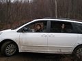
Making a "100-point turn" to get out of the mud!
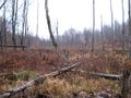
The woods. It's actually a bit swampish.
A beaver dam!
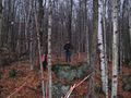
King of the rock?
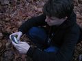
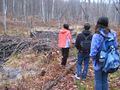
Randall checks our position.
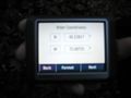
We made it! Sorry it's blurry!
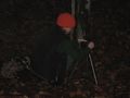
Scout sets up the tripod.


